| Name | Abstract title posters | Poster |
|---|
| Rim, Donsub |
A Stability Analysis of Neural Networks and Its Application to Tsunami Early Warning |  |
| Sherwood, Chris |
Conceptual Model for Revegetation of Barrier Islands after Outwash and Overwash Events |  |
| Ghoshal, Suryodoy |
From Earthquakes to Landslides: Predictive Modeling and Applications |  |
| Wanderley de Almeida, Matheus |
From flames to flux: how wildfires alter soil formation and sediment dynamics |  |
| Amaya-Saldarriaga, Anderson |
Influence of Vegetation-Induced Roughness on the Morphodynamics of River-Dominated Deltas |  |
| Pamula, Abhiram Siva Prasad |
Data-driven Monitoring of Green Stormwater Infrastructure using Remote Sensing and AI Techniques |  |
| Haghiri, Mohammad |
Simulation of seasonal water table dynamics Across North America using the Water Table Model (WTM) |  |
| Khalifa, Ahmed |
Investigation of the environmental impact of annual sea level rise variability on the deltaic landscape evolution in estuarine environments | 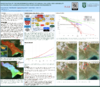 |
| Oliveira, Pedro |
“Dating the Incision of the Lower Amazon River using geomorphic markers and cosmogenic nuclides” |  |
| Marggraf, Jessica |
Using flume and field measurements to estimate bedrock susceptibility to erosion |  |
| Joshi, Ayush |
Bridging Temporal Gaps: TL Thermochronology as a Key to Active Tectonics and Knickpoint Migration in the San Gorgonio Pass |  |
| Martin, Jo |
Neural Networks Can Infer Geomorphic Model Parameters From Topography, and We Might Be Able To Figure Out How! |  |
| Goldstein, Evan |
Detecting inland coastal flooding with TinyCamML, a low-cost, privacy-aware camera with on-device ML and cellular connectivity |  |
| Byun, Jongmin |
Effects of Relief on Headwater Catchment Landscapes |  |
| Bui, Viet |
Quantifying Delta Planform Evolution Under Sea-Level Rise: Insights from Flume Experiments and Enthalpy-Based Modeling |  |
| da Silva, Renato |
RiverCaptureFinder: A New Tool for Identifying and Classifying Drainage Captures in Landscape Evolution Models |  |
| Callaghan, Kerry |
Global change in groundwater and lake storage over the past 21,000 years |  |
| Leung, Meredith |
Co-producing a Mauka (Mountain) to Makai (Sea) Interconnected Systems Modeling Framework for Informed Management in a Changing Climate |  |
| Ashrani, Uma |
Simulating Ditch Removal and Wetland Restoration Using Depression-Filling Algorithms |  |
| Carchipulla-Morales, David |
A novel model uncovers the importance of dew deposition for canopy epiphytes in a tropical montane cloud forest |  |
| Murray, Brad |
Theoretically and Empirically based modeling of the evolution of multi-species marshes |  |
| Arcuri, Josie |
Using a hydraulic model to identify the formative discharge for gravel-bedded rivers that fill with ice | 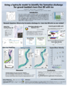 |
| Bogan, Abner |
Advancing FAIR Research Software Practices in Hydrology Domain through Metadata Standardization and Evaluation |  |
| Armstrong, William |
Basal motion modulates glacier change in a warming climate | |
| Borse, Dnyanesh |
Hierarchical Link Length Distribution Controls Dynamic Connectivity Across Channel Networks | |
| Boulton, Sarah |
Exploring the role of normal faulting and strong lithological contrasts on landscape transience using Landlab. | |
| Cang, Xuezhi |
Landscape Structure Through Depression Hierarchy Analysis in the Continental United States | |
| Chen, Qiuyang |
Customizing River Corridor Segmentation from Satellite Imagery Using Deep Learning | |
| De Santos, Carisa |
Variability in Winds During River Flood and Quiescent Periods in Baltimore, MD: Implications for Modeling Estuarine Residence Time | |
| Grom, Vivian |
Quantifying Spatial and Temporal Variation in LEM Outputs | |
| Haque, Dewan Mohammad Enamul |
Advancing dynamic multi-(hazard-) risk assessment method for a massive refugee camp in Bangladesh | |
| Henry, Hannah |
The Effect of Climate and Management Strategies on Barrier Island Evolution: Insights from a Case Study of Hatteras Island | |
| Huang, Qin |
Modeling Fire Dynamics, Human Behavior, and Power Supply in Complex Systems Using Agent-Based Models (ABMs) | |
| Huffman, Emily |
Modeling the environmental controls of uplifted beach ridge geomorphology | |
| Iscen, Nilay |
Equilibrium Geometry of Sand-Bed Rivers: Insights from Morphodynamic Controls and SRLP | |
| Kelley, Madeline |
First Application of AeoLiS to Fluvial-Aeolian Systems | |
| Langhorst, Theodore (Ted) |
Estimating Daily Suspended Sediment Flux from Multiple Data Sources using Deep Learning | |
| LeVeque, Randall |
Tsunami Early Warning from GNSS Data using Convolutional Neural Networks | |
| McDougall, Dylan |
Coupling Cross-shore and Alongshore Processes to Explore Long Term Coastline Morphodynamics | |
| Messina, Francesca |
Sediment Infilling Rate of Lowermost Mississippi River Borrow Pits and Impacts on Downstream Dredging | |
| Minear, J. Toby |
The NASA SWOT Satellite Mission and Fluvial Geomorphology | |
| Mitchell, Hamish |
Constructing Digital Elevation Models from Single Synthetic Aperture Radar Images | |
| Morey, Susannah |
Magnitude Matters: examining landsliding magnitude-frequency relationships and their impacts on mountain landscapes | |
| Quigley, Louis |
NDVI as a proxy for Hydrological Drought Monitoring around Cape Town, South Africa | |
| Reahl, Jocelyn |
Surface mass balance–driven ice flow emulator underpredicts terminus retreat at lake-terminating glaciers | |
| Rengers, Francis |
Using Big Data for Postfire debris flow situational awareness | |
| Said, Mohamed Fathi |
Accelerate Bed-Change Simulations Using Spatiotemporal Deep Learning Framework | |
| Schanta, Ryan |
Leveraging FUNWAVE-TVD Outputs as Training Data for Nearshore ML Models | |
| Shacheri, Fatemeh |
Comparative Influence of Channel Morphology and Sediment Lithology on Downstream Sediment Impacts in Several Rivers of Washington State | |
| Shmilovitz, Yuval |
Ecohydrology and lithological controls on ephemeral catchments landscape evolution: insights from the High Plains (Colorado) using high-resolution climate projections | |
| Shobe, Charles |
Modeling the influence of macro-roughness on gravel-bed river morphodynamics | |
| Song, Yalan |
High-Resolution Differentiable Models for Operational National and Global Water Modeling and Assessment | |
| Steckler, Mike |
Future projections of compaction-induced subsidence on the Ganges-Brahmaputra Delta | |
| Sulca, Debbie |
Contaminant Transport Characterization at Los Alamos National Laboratory using a Vadose Zone Vapor Plume Model | |
| Tull, Nelson |
An open-source approach for modeling dynamic vegetation processes in coastal environments | |
| Undzis, Brianna |
Source Composition of Suspended Sediment Concentrations on the Alaskan Beaufort Sea Shelf | |
| Volponi, Sabrina |
No abstract submitted yet | |
| Westoby, Matt |
Using CAESAR-Lisflood to model the geomorphic recovery of a high-mountain fluvial system following an extreme sediment-charged flow | |
| Wu, Zhenwei |
Morphodynamic Response of River Deltas to Unsteady Discharge and Sediment Supply | |
| Yadav, Anshul |
Flow-driven bedload: A numerical study of monodisperse and bidisperse grain kinematics | |
| Zhang, Jiaye |
Large-Eddy Simulation of Bedform Evolution Driven by Turbulent Coherent Structures in an Oscillatory Flow | |


