2025 CSDMS meeting-132
From CSDMS
(if you haven't already)
Log in (or create account for non-CSDMS members)
Forgot username? Search or email:CSDMSweb@colorado.edu
Browse abstracts
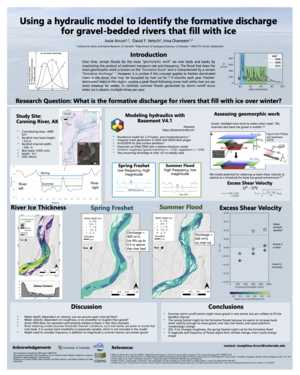
Using a hydraulic model to identify the formative discharge for gravel-bedded rivers that fill with ice
Josie Arcuri,
(She/Her),INSTAAR Boulder Colorado, United States. Josephine.Arcuri@colorado.edu
Irina Overeem, INSTAAR BOULDER Colorado, United States. Irina.Overeem@colorado.edu
David Vetsch, ETH Zurich Zurich , Switzerland. vetsch@vaw.baug.ethz.ch
Gravel-bedded rivers are shaped during floods. Over time, certain floods do the most “geomorphic work” on river beds and banks by maximizing the product of sediment transport magnitude and frequency. The flood that does the most geomorphic work is known as the “formative flood” - it may not be the peak, but it reoccurs more often. However, it is unclear if this concept applies to freshet-dominated rivers in the Arctic. Gravel-bedded rivers in the Arctic continuous permafrost zone are occupied by river ice for 7-9 months each year. Freshet-dominated rivers in this region, like the Canning River, AK, receive a peak flood following snow melt while river ice can resist breakup for weeks, extending flood duration and magnitude. Still, the spring freshet occurs when hydraulic cross-sections are restricted by bedfast ice, limiting bed and bank exposure, but maximizing stage height. In contrast, summer floods generated by storm runoff occur when ice is absent, multiple times per year. Still, river bank and bed gravel is coarse and difficult to transport under low flows. We aim to investigate which flood maintains the Canning River’s hydraulic geometry, and more generally the hydraulic geometry of all ice-impacted, gravel-bedded rivers.
We explore if there is a formative flood for rivers that develop bedfast river ice with Basement V4. We focus on a 20 km reach of the Canning River in Arctic Alaska, where we monitored break-up period from 2021 through 2024. We use USGS data for realistic peak discharges, ArcticDEM for surface topography, and field measurements of river ice thickness to drive the model. We assess geomorphic significance of bedfast river ice with metrics for potential sediment transport along river bank toes - the main process eroding river banks in this setting.
Initial results suggest that even extreme floods are unlikely to fill the bankfull channel or erode river banks when the channel is free of ice. Conversely, we find that up to 1m of river ice during the spring freshet can induce bank erosion, under a constant discharge of 900 m3/s. For the Canning River, the spring freshet is likely the formative flood. Our findings also suggest that the recurrent development of bedfast river ice over winter leads to wider rivers.