Labs portal
Want to contribute your own lab? Please contact irina.overeem@colorado.edu
| Labs | ||
|---|---|---|
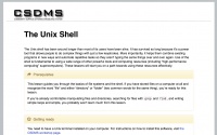 |
Get Started with Unix Shell
These lessons will show you how to navigate and manipulate files and the file system through the Unix Shell and the basics of cluster computing. These skills are fundamental for using the CSDMS HPCC. Shell Tutorial | |
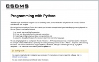 |
Get Started with Python
These lessons cover the basics of using Python 2.7 for numerical modeling. Some previous experience in scientific programming is helpful but not necessary. Python Tutorial | |
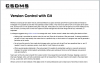 |
Get Started with Version Control
These lessons teach you the basics of Version Control using Git and Github. Version Control Tutorial | |
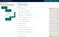 |
Get Started with WMT
This tutorial teaches you how to use CSDMS Web Modeling Tool; it is focused on how to use the WMT software. WMT tutorial | |
 |
Visualize NetCDF Output from WMT
This tutorial teaches you how to visualize output from CSDMS Web Modeling Tool; it shows examples of NetCDF output and how to plot them in Panoply . Visualize NetCDF Output from WMT | |
 |
Sediment Supply to the Global Ocean
Investigate river sediment supply to the ocean by exploring the effects of climate changes on river fluxes. We also look at the effect of humans on rivers: the building of a reservoir. Spreadsheet Lab or the HydroTrend Modeling with WMT | |
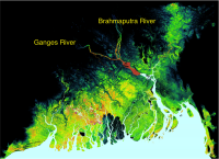 |
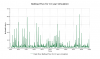
Future Sediment Flux of the Ganges River
Investigate river sediment supply of the monsoon-driven Ganges River. Exploring the effects of future climate changes. We validate model against observations and discuss uncertainty. Ganges Modeling with WMT | |
 |
Hydrology and Energy Balance
Introduction to hydrological process modeling. Learn about incoming solar radiation and the effects of watershed latitude, and local slopes and aspects on the energy balance. Hydrology Modeling with WMT | |
 |
Hydrology and Flow Routing
Learn about flow routing over a landscape and basic algorithms for numerical modeling of combined hillslope and river sediment transport processes. WMT Modeling Exercise on flow routing
| |
 |
Stream Response to Rain
Introduction to hydrological process modeling. Learn about stream responses to different rainfall events. Explore hydrographs. Modeling Stream Response to Rainfall | |
 |
Spreadsheets on Hydrological Processes
These spreadsheet exercises for undergraduate students explore the main components of the water balance: precipitation, evaporation and infiltration.
Exercise on Evaporation | |
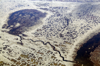
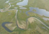
| [[File:Barrierislandevolution.png | left]] | Barrier Island and Salt Marsh Dynamics
Look at model simulations to explore the effects of sea level rise, river water and sediment influx and storm activity. With lesson plan and activities for high school students and first year undergraduate students.
Start the activity |
 |
ROMS-Lite Modeling: learning about grids
A basic configuration of the Regional Ocean Modeling System is designed for inexperienced modelers to look at a river plume affecting the coastal ocean and sediment transport. Learn about ROMS in WMT | |
 |
ROMS-Lite Modeling: settling rates and shear stress
A basic configuration of the Regional Ocean Modeling System is designed for inexperienced modelers to look at sediment settle rates and shear stress in the coastal ocean. Learn about ROMS in WMT | |
 |
ROMS-Lite Modeling: wave forcing
A basic configuration of the Regional Ocean Modeling System with special focus on the effect of waves on bed stresses and sediment transport in the coastal ocean. Learn about waves with ROMS | |
 |
ROMS-Lite Modeling: river forcing
A basic configuration of the Regional Ocean Modeling System with special focus on the effect of varying river inflow in the coastal ocean. Learn about flood discharge and ocean conditions with ROMS | |
 |
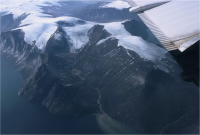
Permafrost Modeling: where does permafrost occur?
What is permafrost and how do you make a first-order prediction about permafrost occurrence. This is lesson 1 in a mini-course on permafrost, this lab uses the Air Frost Number and annual temperature data to predict permafrost occurrence. Model permafrost occurence in WMT | |
| Permafrost Modeling: the Active Layer
Explore what is active layer depth and the effects of snow and soil water content on permafrost. This is lesson 2 in a mini-course on permafrost. It employs a 1D configuration of the Kudryavtsev model. Model active layer thickness and its controls in WMT | ||
 |
Permafrost Modeling: making maps from gridded climate data
Using the Frost number code and grids of climate input data, one can make predictions of permafrost occurrence over the last century in Alaska. This is lesson 3 in a mini-course on permafrost. Create maps of permafrost using climate reanalysis grids in WMT | |
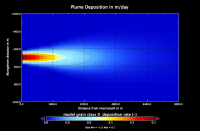 |
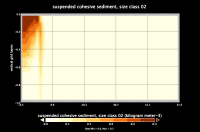
Modeling River Plumes
Riverwater and its suspended sediments will form a hypopycnal sediment plume. We will use a component called PLUME to investigate the behavior of these sediment plumes. Plume Modeling with WMT | |
 |
Sinking Deltas
Deltas experience rapid sea level rise. These spreadsheet exercises explore thermal expansion, global sea-level rise and local relative sea-level rise and its causes in selected major deltas. For undergraduate level classes. Notes for students and instructors and spreadsheet exercise | |
 |
River-Delta Interactions
Explore coastal processes by 1) a spreadsheet lab or 2) an advanced modeling lab using the CEM model. We look at the effects of waves and river avulson on the coastline. Spreadsheet Lab or the CEM WMT modeling | |
 |
Stratigraphic Modeling with Sedflux2D
SedFlux builds stratigraphy by combining fluvial processes, plume dynamics, ocean waves and many more. This lab teaches you about Sedflux 2d and gets you started building 2D profile simulations of sea level change. Stratigraphy Modeling in 2Dwith WMT | |
 |
Stratigraphic Modeling with Sedflux3D
SedFlux builds stratigraphy by combining fluvial processes, plume dynamics,avulsion, compaction and many more. This lab teaches you about Sedflux 3d and gets you started with sea level change and avulsions. Stratigraphy Modeling in 3D with WMT | |
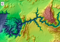 |
Landscape Evolution Experiments
WILSIM is a Web-based Interactive Landform Simulation Model. Look at the effects of landscape geometry, climate and tectonics and see how the Grand Canyon forms over time. WILSIM runs through your browser here | |
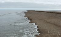 |
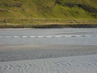
Coastal Engineering Experiments
Explore waves, surge, tides and sediment transport with hands-on exercises and simple model visualizations.
Find them here Coastal Processes Toolbox of Tony Dalrymple | |
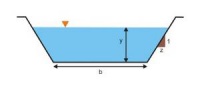 |
Hydraulics and Sediment Transport Calculations
Explore hydraulics, pipe flow and sediment transport with hands-on calculation and simple model visualizations.
Find them here VLab of Victor Miguel Ponce
| |
 |
Simple Sediment Transport Models
Here we are collecting sediment transport modeling exercises | |
 |
Landscape Evolution Modeling with CHILD, Part 1
| |
 |
Landscape Evolution Modeling with CHILD, Part 2
| |
 |
Landscape Evolution Modeling with CHILD, Part 3
| |
 |
River Dynamics and Vegetation labs for K6-12
Lectures show basics of river water and sediment transport, focused on a small river in the Arid West, the Rio Puerco. Associated hands-on labs look at the complex interactions of the biosphere and hydrosphere. Materials are posted here . | |
 |
Agent-Based Models for Earth Surface Processes
Want to learn more about human dimensions? Check out the 'Swidden Agricultural Model', the 'Commons model' and the Wealth Distribution models as examples of ABM COMSES models are found here.' | |
 |
Modeling Uncertainty in Earth Sciences
A set of 5 labs on different aspects of model uncertainty: basic statistics, decision making, variograms, and sensitivity testing. This is material designed by Jef Caers and accompagnies his textbook. | |
 |
Earth Science Models for K6-12
The PhET project at CU Boulder has built numerous interactive simulations to which CSDMS scientists contribute. These are for K6-12 classrooms! PhET Earth Science simulations are found here.
| |
