Lab-0006
From CSDMS
Future Sediment Flux of the Ganges River
Contributor(s)
Introduction
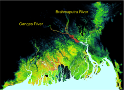

The Ganges-Brahmaputra Delta is one of the largest deltas in the world. In Bangladesh alone, 160 million people live in the floodplains. The Ganges and Brahmaputra Rivers and their delta are strongly impacted by the Asian summer monsoon. Widespread hazards relate to the intense seasonal rainfall: flooding, river erosion and channel switches. The people of Bangladesh have adapted to this dynamic delta system, they have raised villages above the annual flood level and embanked agricultural land.
Classroom organization
This lab investigates 1) the modeling of the incoming water and sediment load of the Ganges river, 2) the validity of model output compared to real-world observations, and 3) how future changes in the monsoon possibly affect this sedimentary system and 4) we try to assess the uncertainty of such predictions.
This lab will run HydroTrend simulation with Python Modeling Tool (Pymt). If you have never used the Pymt, learn how to use it: https://pymt.readthedocs.io/en/latest/install.html. The Pymt allows you to set up simulations and run notebooks.
If you are a faculty at an academic institution, it is possible to work with us to get temporary teaching accounts. Work directly with us by emailing: csdms@colorado.eduLearning objectives
Skills
Skills
- use Pymt to run HydroTrend Model
- familiarize with a basic configuration of the HydroTrend Model
- make small changes to key input parameters
- hands-on experience with visualizing output in Python
Key concepts
- Simulation of the river discharge for Ganges River
- Simulation of the suspended sediment discharge for Ganges River
- What is the mean annual flow for Ganges River
Lab notes

>> Open a new browser window and open the Pymt read the docs page: https://pymt.readthedocs.io/en/latest/examples.html
>> You will see that there are several example models. In this lab we will select the HydroTrend model.
>> Click on the 'Launch Binder' box and it will allow you to see this lab as a Jupyter Notebook.
>> You can execute the Jupyter notebook code cells using shift -enter.Requirements
--
References
- Kettner, A.J., and Syvitski, J.P.M., 2008. HydroTrend version 3.0: a Climate-Driven Hydrological Transport Model that Simulates Discharge and Sediment Load leaving a River System. Computers & Geosciences, 34(10), 1170-1183. doi: 10.1016/j.cageo.2008.02.008
