HPCCprojects:Niger Delta Project: Difference between revisions
From CSDMS
mNo edit summary |
mNo edit summary |
||
| Line 13: | Line 13: | ||
__NOTOC__ | __NOTOC__ | ||
={{PAGENAME}}= | ={{PAGENAME}}= | ||
==Project description== | ==Project description== | ||
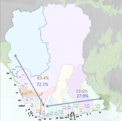
# Acquire and analyze precipitation, evapotranspiration and discharge data from available sources, for the Niger Delta. | |||
# Determine the runoff entering the delta system from upstream sources, versus local-derived rainfall. | |||
# Analyze Shuttle Radar (SRTM) topography along with other satellite data (e.g. LANDSAT) to assess the dimensions of the Niger distributary channels. | |||
# Develop a hydrological model for the Niger Delta area to handle distributary channels efflux. Using satellite imagery, ascertain the local drainage basins for each of the major Niger Delta estuaries. | |||
# Couple the hydrological model with a simplified semi-diurnal tidal model and develop a time-dependent flow routing model of the Niger Delta. | |||
# Model the time dependent sediment load to the Niger Delta, and distribute the load through the various distributary channels. | |||
# Qualitatively verify sediment flux predictions using satellite imagery of both channel turbidity, and plume turbidity. | |||
# Apply the PSI model (Syvitski et al., 2005a; Kettner and Syvitski, 2008) to the hydrological flow routing model of the Niger Delta and predict the flux of sediment through the various distributary channels. | |||
==Objectives== | ==Objectives== | ||
Determine the dispersal mechanisms of the terrestrial flux of sediment and the coastal trapping of sediment of deltaic distributary channels with focus on the Niger Delta. Conduct a hydrological assessment of the fluxes of water and sediment to the shorelines of Niger Delta, Nigeria. Assess the timing of discharge events, suspended load and bed load. | |||
==Time-line== | ==Time-line== | ||
| Line 24: | Line 33: | ||
==Models used== | ==Models used== | ||
[[Model:TopoFlow|TopoFlow]] | * [[Model:TopoFlow|TopoFlow]] | ||
* [[Model:HydroTrend|HydroTrend]] | |||
==Results== | ==Results== | ||
Revision as of 16:32, 4 November 2010
Niger Delta Project
Project description
- Acquire and analyze precipitation, evapotranspiration and discharge data from available sources, for the Niger Delta.
- Determine the runoff entering the delta system from upstream sources, versus local-derived rainfall.
- Analyze Shuttle Radar (SRTM) topography along with other satellite data (e.g. LANDSAT) to assess the dimensions of the Niger distributary channels.
- Develop a hydrological model for the Niger Delta area to handle distributary channels efflux. Using satellite imagery, ascertain the local drainage basins for each of the major Niger Delta estuaries.
- Couple the hydrological model with a simplified semi-diurnal tidal model and develop a time-dependent flow routing model of the Niger Delta.
- Model the time dependent sediment load to the Niger Delta, and distribute the load through the various distributary channels.
- Qualitatively verify sediment flux predictions using satellite imagery of both channel turbidity, and plume turbidity.
- Apply the PSI model (Syvitski et al., 2005a; Kettner and Syvitski, 2008) to the hydrological flow routing model of the Niger Delta and predict the flux of sediment through the various distributary channels.
Objectives
Determine the dispersal mechanisms of the terrestrial flux of sediment and the coastal trapping of sediment of deltaic distributary channels with focus on the Niger Delta. Conduct a hydrological assessment of the fluxes of water and sediment to the shorelines of Niger Delta, Nigeria. Assess the timing of discharge events, suspended load and bed load.
Time-line
Start date: 2008
End date: 2010
Models used
Results

|
| Niger Delta drainage basins and outlets |
Users
Funding
--
Publications and Presentations
--
Links
This would be the place to provide links that are related to your project.
Choose one of the two categories mentioned below, that your project suites the best
