Template:TEXT BOX LEFT: Difference between revisions
From CSDMS
No edit summary |
No edit summary |
||
| Line 1: | Line 1: | ||
[[Image: | [[Image:FLACfish.png |200px|left|link=Science_spotlights#Mountain_Growth_Separates_Fish_Populations]] | ||
A new study published in Nature Geoscience offers rare evidence to show that tectonic evolution drives abrupt river drainage captures, which then separate freshwater fish species that further evolve in isolation. CSDMS Geodynamics Working Chair, Phaedra Upton, used FLAC3D to demonstrate that six tectonic zones evolved with distinct river drainages on New Zealand’s South Island. These topographic reconstructions were then combined with analyses of the evolutionary tree of freshwater fish populations from each of the catchments, to show that the fish DNA sequences diverge synchronously with the growth of the mountains. [[Science_spotlights#Mountain_Growth_Separates_Fish_Populations|More...]]<br><br>[mailto:csdmsweb@colorado.edu Nominate a science spotlight] | |||
Revision as of 18:07, 1 January 2016
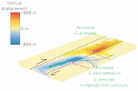
A new study published in Nature Geoscience offers rare evidence to show that tectonic evolution drives abrupt river drainage captures, which then separate freshwater fish species that further evolve in isolation. CSDMS Geodynamics Working Chair, Phaedra Upton, used FLAC3D to demonstrate that six tectonic zones evolved with distinct river drainages on New Zealand’s South Island. These topographic reconstructions were then combined with analyses of the evolutionary tree of freshwater fish populations from each of the catchments, to show that the fish DNA sequences diverge synchronously with the growth of the mountains. More...
Nominate a science spotlight
