Science spotlights
Science spotlights
A sediment load model for the world’s drainage basins
Science in the spotlight: June 2012 - July 2012
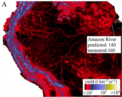
This model predicts suspended sediment loads, which are critical for assessment of land-use, soil erosion and river sediment discharge. In turn, the incoming sediment greatly affects the state of deltas at the downstream end. The presented model is spatially-distributed, and runs over a 5 arc minute SRTM digital elevation model, which allows better understanding of storage of sediment along its way to the ocean on the decadal timescale. The resolution of the data makes the model appropriate for medium-scale catchments (>1000-10,000 km2) and larger river basins.
One new aspect of the recently published model is the inclusion of vegetation cover by using a Leaf Area Index derived from a gridded remotely-sensed dataset of a Normalized Difference Vegetation Index from 1981-2006. The model then assumes an inverse, but stochastic, relationship between Leaf Area Index and soil detachment, i.e. more leaf layers lead to less erosion potential. Dr. Pelletier innovatively uses a new global datasets for soil texture: the Harmonized World Soils Map (see more info in the CSDMS data repository: http://csdms.colorado.edu/wiki/Data:HWSD) to constrain grainsize parameters, which impact efficiency of river transport.
The paper compares model predictions with existing river sediment load databases for natural or pre-dam conditions. The author concludes that the presented simple regression model with two free parameters performs relatively well. Just using one example, the Amazon River shows most of the basin sediment yield originating from the narrow Andes Mountain Range. The model predicts a yield of 140 t/km2 per year close to the Amazon river mouth, whereas the measured yield is 160 t/km2 per year. The author extensively discusses model shortcomings and potential improvements ranging from inclusion of reservoir and dam data, as well as incorporating quantitative relationships for uplift rates and landslides.
References
- Pelletier, J., 2012. A spatially distributed model for the long-term suspended sediment discharge and delivery ratio of drainage basins. Journal of Geophysical Research, Vol 11, 117, F02028.
Links
- Meet the author:Jon Pelletier' homepage
Elwha River restoration, the largest dam removal project in North America
Science in the spotlight: February 2012 - April 2012
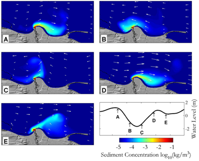
Since the dams were built the Elwha River delta has experienced shoreline erosion, reduced sediment available to be moved along the coast via longshore transport, and a coarsening of the delta substrate. Gelfenbaum and others’ simulations predict post dam removal shoreline erosion rates may slow and even stop. A range of sediment sizes will accumulate at rates of up to 1 cm per year near the river mouth. Interestingly while sedimentation rates diminish away from the mouth of the river the tip of a nearby spit of land, Ediz Hook is modeled to receive increased sedimentation rates of approximately 0.5 cm per year. The stability of this hook is critical to the city of Port Angeles, that relies on the natural embayment created by it to provide a calm harbor for ships using the port of Port Angeles, and for others that use it to wait for favorable tides before proceeding on to other ports throughout the Puget Sound region.
References
- Gelfenbaum, G., Stevens, A.W., Elias, E., and Warrick, J.A., 2009. Modeling sediment transport and delta morphology on the dammed Elwha River, Washington State, USA. Proceedings of Coastal Dynamics 1-15, doi:10.1142/9789814282475_0109
Links
- A range of USGS publications on the Elwha River, including Gelfenbaum et al 2009 can be found at http://walrus.wr.usgs.gov/elwha/publications.html
- Link to animation of suspended sediment plume over 72 hour period http://pubs.usgs.gov/sir/2011/5120/5.13/player.html
Irreversible Peatland Subsidence Depends on Water Management
Science in the spotlight: November 2011 - January 2012
Understanding subsidence of peat-rich coastal areas due to bio-oxidation is of great importance, because of increased risk of flooding with rapid sea level rise, because of saltwater intrusion from nearby estuaries and lagoons, and because of net CO2 production with oxidation.
Detailed field observations of ground level and meteorological and soil conditions on peat-rich farmland nearby the Venice Lagoon in Italy over 2002-2006 show that with wetting and drying due to rainstorms significant, but reversible subsidence occurs. Peat expands with wetting and decreases as the water table drops subsequently. These elastic deformations due to pore pressure variations amount upto 5 mm over a few days to 2 weeks, and can be well modeled with a new numerical approach presented in the Journal of Geophysical Research paper (Zanello et al., 2011).
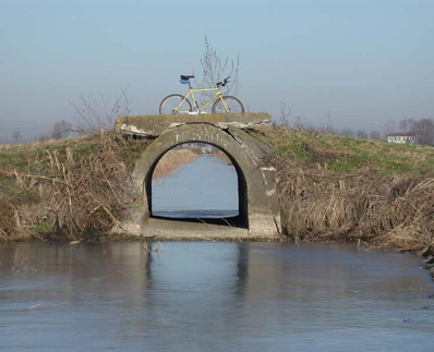
Irreversible loss over the period of measurement amounts upto 30 mm in 4 years. Subsidence has been ongoing over the last 70 years after this area was claimed for agricultural use. The exposed foundation of the small bridge on the photo illustrates how cumulative subsidence can be >1m, it now prohibits efficient drainage. A model quantifies the relationship between peat layer properties, water table (management) and temperature to predict bio-oxidation rates. It was found that most oxidation happens due to dry, warm conditions. The simulations indicate that for a given peat soil, oxidation is mostly influenced by a low water table levels. This result has important implications for hydrological management of peaty lowlands, less subsidence will occur under waterlogged conditions.
References
- Zanello, F., Teatini, P., Putti, M., Gambolati, G., 2011. Longterm peatland subsidence: experimental study and modeling scenarios in the Venice coastland. Journal of Geophysical Research, 116, F040002, doi:10.1029/2011JF002010
Links
- project website: Project website (mostly in Italian)..
New Modeling Textbook
Science in the spotlight: September 2011 - October 2011
The newly published textbook: “Mathematical Modeling of Earth's Dynamical Systems: A Primer” by Slingerland and Kump helps earth scientists build essential skills to represent Earth surface processes with mathematical and computational models.
The book aims at upper-level undergraduate students, graduate students, and scientists who want to learn how to abstract complex earth systems into sets of dynamic equations. It is clear that the authors do aim at an audience that is familiar with the principles of physics, chemistry, and geology, and expect some background in differential and integral calculus. But the authors stress that little prior modeling experience is needed to use this book; they want to instill a philosophy of science that values quantification as a way of gaining insight.
That philosophy rings true. The authors step aspiring modelers systematically through quantitative problem solving process. Firstly, get the physical picture clear while recognizing domains of interest and key factors, then write down the mathematical laws, be aware of the restrictive assumptions, check your units and boundary conditions and lastly verify, validate and solve your model.
Various relevant examples of processes and systems are provided with increasing complexity over the chapters. Slingerland and Kump offer problems over the entire Earth System Science domain in choosing groundwater flow, coastline evolution, sediment transport, radioactive decay, and carbon flux modeling problems as their rich set of examples. Every chapter has modeling assignments for eager modelers to try their newly acquired insight, or for teaching faculty to assign to their students. Slingerland and Kump are the “top chefs” who present a cookbook with their favorite basic recipes for earth surface modelers. Taste these, feed the inner quantitative modeler and enjoy.
The Princeton University Press quotes: "Written by two of the leading researchers in the field, Mathematical Modeling of Dynamical Systems is a must-read for all geoscientists, and not just students. This excellent primer offers bite-size gems of insight into the world of quantitative geosciences applications, covers both mathematical and modeling concepts, and offers practical exercises to build expertise. Course notes and methodologies will be improving across our academies."--James P. M. Syvitski, executive director, Community Surface Dynamics Modeling System
References
- Slingerland, R., Kump, L., 2011. Mathematical Modeling of Earth's Dynamical Systems: A Primer.
Princeton University Press. ISBN 978-0-691-14514-3.
Links
Where do Salmon thrive?
Science in the spotlight: June 2011 - July 2011
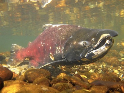
The Merced River in the Central Valley of California has been highly impacted by damming, gravel mining and placer mining over the last 150 years. River restoration projects along the Robinson Reach of the Merced River have focused on restoring the river to more natural conditions by excavating a 2.25km long single-thread, meandering channel with riffles and pools. Restoration was completed in January 2002. Dams in the upstream areas still dominate the flow conditions, with short releases of high water and mostly sustained low water. Two more extensive spring flood events with sustained overbank flows for several weeks occurred post-restoration.
A team of scientists from University of California, Santa Barbara, the California Polytechnical State University and the University of Wyoming used repeat observations of channel morphologies to condition flow simulations with FastMech-the Multidimensional Surface Water Modeling System developed by the USGS (a.o. Barton et al., 2005). Harrison and co-authors coupled the flow simulations to habitat criteria for Salmon spawning and rearing. Salmon prefer shallow riffles of ~50 cm for spawning, whereas optimal young salmon rearing habitat is in pools greater than 75 cm depth with lower flow velocities. Model simulations showed that substantial bar growth and migration occurred during the two flood events. Pointbars that were formed during flood are now favorable habitats at low flows, especially for spawning; 70% of the restored river stretch now has good habitat conditions for spawning. The coupled model predictions show that the restored channel has still less optimal conditions for Salmon rearing. Juvenile salmon need small-scale morphological features, which slow down the flow velocity.
References
- Harrison, L. R., C. J. Legleiter, M. A. Wydzga, and T. Dunne (2011), Channel dynamics and habitat development in a meandering, gravel bed river, Water Resour. Res., 47, W04513, doi:10.1029/2009WR008926.
- Barton, G. J., R. R. McDonald, J. M. Nelson, and R. L. Dinehart (2005), Simulation of flow and sediment mobility using a multidimensional flowmodel for the white sturgeon critical habitat reach, Kootenai River near Bonners Ferry, U.S. Geol. Surv. Sci. Invest. Rep., 2005‐5230.
Links
Retreating Arctic Coasts
Science in the spotlight: April 2011 - June 2011
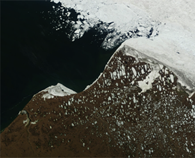
The coastline in Arctic regions reacts to climate change with widespread increased erosion by 0.5 m per year. Coastal change is particularly dramatic in the Laptev, East Siberian and Beaufort Seas, where coastal erosion rates reach more than 14 m/year. Since around a third of the world’s coasts are located in the Arctic permafrost, coastal erosion may affect enormous areas in future. In general Arctic coasts react more sensitively to global warming than coasts in the mid-latitudes. Up to now these coasts have been protected against the eroding force of the waves, and warm sea water by sea ice cover. Due to the continuous decline in sea ice area extend, this protection is jeopardized.
Two thirds of the Arctic coasts consist of frozen sediments. And precisely these coasts are extremely hard hit by erosion. As a rule, Arctic regions are quite thinly populated. However, as nearly everywhere in the world, the coasts in the far north are important axes for economic and social life. The growing need for global energy resources as well as increasing tourism and freight transport additionally intensify anthropogenic influence on the coastal regions of the Arctic. For wild animal stocks, like the great caribou herds of the north, and the widespread freshwater lakes near the coast progressive erosion brings about significant changes in ecological conditions. More than thirty scientists from ten countries were involved in preparing the 170-page status report entitled “State of the Arctic Coast 2010”. The study was initiated and coordinated by the International Arctic Science Committee (IASC), the international joint project Land-Ocean Interactions in the Coastal Zone (LOICZ), the International Permafrost Association (IPA) and the Arctic Monitoring and Assessment Programme (AMAP) working group of the Arctic Council.
Links
- http://www.loicz.org/press/index.html.en
- http://www.arcticcoasts.org/
- PDF of report
- Article in 360 environment: As arctic sea ice retreats storms take toll on the land
Movies of coastal retreat can be found in the CSDMS EKT repository:
Boom-and-bust cycles of barrier island retreat
Science in the spotlight: December 2010 - April 2011
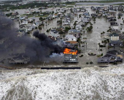
Barrier Islands, the low-lying sandy strips separated from the coast by a lagoon, are a favorite location to build beach resorts. Whereas a natural barrier system would steadily migrate with sea-level rise, barriers evolution is now dynamically coupled to human action to prevent storm erosion. CSDMS scientist Dylan McNamara, currently at the University of North Carolina, has been on the forefront of coupled modeling of barrier island physical processes and human factors such as hazard mitigation driven by market development.
McNamara’s model shows that barrier island are maintained at unnaturally low elevations and that this situation filters out the frequent small responses to storm events, but that the inherently instability creates longterm boom-and–bust cycles of barrier island retreat.
References
- McNamara, D. and Werner, B., 2008. Coupled Barrier Island-Resort Model: 1. Emergent instabilities induced by strong human-landscape interactions. Journal of Geophysical Research – Earth Surface, 113, F01016, doi:10.1029/2007JF000840.
- McNamara, D. and Werner, B., 2008. Coupled Barrier Island-Resort Model: 2. Tests and predictions along Ocean City and Assateague Island National Seashore, Maryland. Journal of Geophysical Research – Earth Surface, 113, F01017, doi:10.1029/2007JF000841.
