HPCCprojects:Combining a MODIS-based snow water equivalent product and statistical interpolation methods to estimate snowpack and streamflow conditions in the Colorado headwaters
Combining a MODIS-based snow water equivalent product and statistical interpolation methods to estimate snowpack and streamflow conditions in the Colorado headwaters
Project description
We are seeking to develop a SWE monitoring technique that can leverage both point scale measurements and spatially explicit patterns of SWE from remote sensing in near real-time. Current estimates of SWE distribution are frequently interpolated from point measurements based on physiographics with a observations of SCA occasionally used to constrain modeled values. Statistical models relating physiography and SNOTEL SWE only explain up to ~15% of the observed variability and thus these techniques provide limited credibility for water resource applications. Recent improvements in SWE estimates have been obtained using SWE reconstruction models whereby satellite data of SCA are coupled with fully distributed energy balance modeling to reconstruct peak snow mass. The first goal of this project is to combine a statistical interpolation model with remote-sensing based spatially distributed reconstructed SWE to augment resources available to water managers. The second goal of this project is to incorporate explicitly modeled patterns of SWE and use it as a spatial distribution field for winter precipitation in a streamflow modeling exercise. The intention is to examine the sensitivity and potential improvement in simulated streamflow timing and volume due to an improved representation of the physiographic distribution of SWE.
Objectives
1. Utilize past patterns of observed SWE in conjunction with ground observations to model real-time SWE.
2. Compare streamflow using different SWE products as spatial fields for winter precipitation in a streamflow model.
Time-line
4-5 years. This is part of my PhD work so I hope to wrap up in 2015.
Models in use
I primarily use MATLAB to derive independent variables from a DEM and condition the SNOTEL data for use in statistical models. MATLAB and now R are used for statistical analyses. SNODIS, our SWE reconstruction model, is run in IDL and was written by Bin Guan at the NASA Jet Propulsion Laboratory. The Distributed Hydrology Soil Vegetation Model (DHSVM) will be used for streamflow simulations.
Results
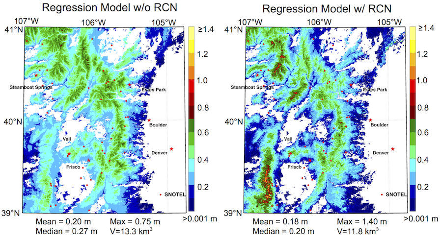
Preliminary results indicate that including the reconstructed SWE as an independent variable in a regression (right) preserves high values of SWE in unsampled areas. Additionally, the range of SWE estimated is greater (lower minimum (dark blue), higher maximum (bright yellow)). In contrast, the regression model with only physiographics (without reconstructed SWE) (left) is only able to interpolate values within the range of observations made at SNOTEL stations, which tend to lay at mid elevations.
Users
Funding
NOAA
Publications and presentations
Schneider, D., N.P. Molotch. (2013) "A regression-based approach for combining ground-based observations, distributed models, and remotely sensed data for real-time SWE estimates." Western Snow Conference, Jackson, WY. Poster.
Schneider, D., N.P. Molotch. (2012) "A regression-based approach for blending remotely-sensed and in-situ snow water equivalent estimates in the Colorado River Basin". AGU Fall Meeting, San Francisco, CA. Poster.

