2019 CSDMS meeting-018
Log in (or create account for non-CSDMS members)
Forgot username? Search or email:CSDMSweb@colorado.edu
Browse abstracts
Recent advances in global-scale hydro-geomorphic riverine modeling
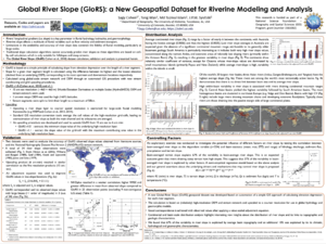
The WBMsed model offers a unique framework for studying river flux dynamics, ranging from basin to global scales. When it was first published in 2013, WBMsed included a spatially and temporally explicit suspended sediment flux module, developed within the WBMplus (FrAMES) hydrological framework. Since then the model has been used for a range of studies and been extended to include a bedload, water density, and particulete nutrients modules. The model's hydrological and geomorphic processes were improved to better represent riverine and landscape dynamics. These include the introduction of a flooding mechanism, spatially-explicit river slope, and land use inputs. Here we will outline these model development and its use for river and coastal studies.
