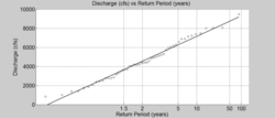
This exercise will provide some experience with methods used for predicting flood frequency and magnitude. We will be using the US Geological Survey (USGS) website to retrieve historical stream gauge data of the sort used to predict the likelihood of flood events of particular magnitudes during a given time interval. Such predictions are the basis for numerous engineering, restoration and development projects in and around rivers. 1. Practice using Python Pandas DataFrames to import, manipulate, and visualize data, 2. Learn some powerful tools for subsetting your dataframes, and 3. Practice visualizing data
Classroom organization This is for an undergraduate geomorphology course (200 level).
You could include requirements that students check their results for the given rivers (Fishing Creek, Tar River, Ellerbe Creek, and Roanoke River) to the USGS calculations for an extended assignment.
I have adapted a lab similar to this one by SERC (https://serc.carleton.edu/hydromodules/steps/168500.html) from T. Perron using excel to analyze flood frequency of a river into python. It would be easy enough to include more background on Wollman & Miller, geomorphic work, the characterstic flood, extreme value analyses, etc dependent on your course interest and focus.