2025 CSDMS meeting-069: Difference between revisions
Created page with "{{CSDMS meeting personal information template-2025 |CSDMS meeting first name=Jo |CSDMS meeting last name=Martin |CSDMS meeting institute=CU Boulder |CSDMS meeting city=Boulder |CSDMS meeting country=United States |CSDMS meeting state=Colorado |CSDMS meeting email address=jo.martin@colorado.edu |CSDMS meeting phone=7733444470 }} {{CSDMS meeting select clinics1 2025 |CSDMS_meeting_select_clinics1_2025=1) Coupled Simulations in ASPECT/FastScape Part 1 }} {{CSDMS meeting sel..." |
No edit summary |
||
| Line 34: | Line 34: | ||
In this work we focus on interpreting the neural network to try to help explain what it is calculating in a theoretically grounded way. The output of activation maximization, Fourier analysis, neuron ablation, and other interpretability techniques are complicated, but might imply that the network is detecting patterns that are geographically meaningful. This poster will present these interpretability results. | In this work we focus on interpreting the neural network to try to help explain what it is calculating in a theoretically grounded way. The output of activation maximization, Fourier analysis, neuron ablation, and other interpretability techniques are complicated, but might imply that the network is detecting patterns that are geographically meaningful. This poster will present these interpretability results. | ||
|CSDMS meeting posterPDF= Jmartin_poster_vertical_2025.pdf | |||
|CSDMS meeting posterPNG= Jmartin_poster_vertical_2025.png | |||
}} | }} | ||
{{blank line template}} | {{blank line template}} | ||
Latest revision as of 10:33, 21 May 2025
(if you haven't already)
Log in (or create account for non-CSDMS members)
Forgot username? Search or email:CSDMSweb@colorado.edu
Browse abstracts
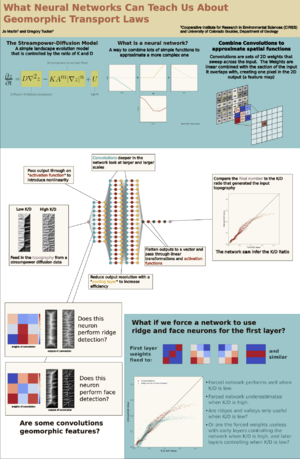
Neural Networks Can Infer Geomorphic Model Parameters From Topography, and We Might Be Able To Figure Out How!
Prior modeling work has found that in 2D models that combine stream incision with diffusive hillslope processes, valley spacing is strongly controlled by the relative rates of advective and diffusive processes (Perron et al. 2008). In this work we train a simple convolutional neural network to predict the ratio of the coefficient of stream erosion (K) and coefficient of diffusion (D) used to generate the model topography. Across a test set of 1800 model runs with different K and D values, the network had a normalized root mean square error of 0.03, showing that convolutional neural networks have significant promise for extracting complex and geomorphically meaningful topographic signatures.
In this work we focus on interpreting the neural network to try to help explain what it is calculating in a theoretically grounded way. The output of activation maximization, Fourier analysis, neuron ablation, and other interpretability techniques are complicated, but might imply that the network is detecting patterns that are geographically meaningful. This poster will present these interpretability results.