Alldata:DBSEABED: Difference between revisions
No edit summary |
No edit summary Tag: Reverted |
||
| Line 3: | Line 3: | ||
|Extended data description=dbSEABED is a data system that describes the material properties of the seabed. It holds data describing over 6 million seafloor sites for the world ocean seafloor. It deals with the sediment textures, strengths and porosities, organic carbon and carbonate compositions, color, mesoscale features, and grain components of the seafloor. dbSEABED extends from shoreline and continental shelf to the abyssal floor, and addresses terrigenous, volcanic and biogenic materials in their rock and sediment forms. By using diverse forms of data, collection and study biases are minimized. | |Extended data description=dbSEABED is a data system that describes the material properties of the seabed. It holds data describing over 6 million seafloor sites for the world ocean seafloor. It deals with the sediment textures, strengths and porosities, organic carbon and carbonate compositions, color, mesoscale features, and grain components of the seafloor. dbSEABED extends from shoreline and continental shelf to the abyssal floor, and addresses terrigenous, volcanic and biogenic materials in their rock and sediment forms. By using diverse forms of data, collection and study biases are minimized. | ||
The project supplies gridded outputs suitable for use in numerical models. The basic set of gridded parameters is: gravel, sand, mud (%), rock exposure (%), average grainsize and sorting (phi), carbonate and organic carbon (%), color red/green ratio. A specification of the parameters is given at | The project supplies gridded outputs suitable for use in numerical models. The basic set of gridded parameters is: gravel, sand, mud (%), rock exposure (%), average grainsize and sorting (phi), carbonate and organic carbon (%), color red/green ratio. A specification of the parameters is given at https://instaar.colorado.edu/~jenkinsc/dbseabed/index.html, | ||
http://walrus.wr.usgs.gov/usseabed/content.html usSEABED, and other web pages and in publications. | |||
At this web site, example gridded outputs are served for the Gulf of Mexico. Serving is done either using | At this web site, example gridded outputs are served for the Gulf of Mexico. Serving is done either using https://github.com/gantian127/bmi_dbseabed BMI dbSEABED or the zipFile (below). | ||
The cell resolution is 0.05 degrees in latitude/longitude projection, using the WGS84 spheroid. Computed griddings of the Standard Uncertainties accompany all the parameter value griddings. Other grid details: ncols 360; nrows 260; cell-centre values; NODATA_value -99. In the file names: 'proj' signifies the project map extent; 'selvg' the map area plus border; 'wiPnts' with point data distribution; 'idw3d' interpolation using the dbSEABED 3D Inverse Distance Weighted method (see dbSEABED documentation). The method uses water depths as well as spatial distances as the interpolation distance metric. Additional steps in the process ensure adequate coastal/inshore data representation and directionally balanced data inputs at each cell. Griddings of the Standard Uncertainty (SU) accompany each value gridding and are available on request. | The cell resolution is 0.05 degrees in latitude/longitude projection, using the WGS84 spheroid. Computed griddings of the Standard Uncertainties accompany all the parameter value griddings. Other grid details: ncols 360; nrows 260; cell-centre values; NODATA_value -99. In the file names: 'proj' signifies the project map extent; 'selvg' the map area plus border; 'wiPnts' with point data distribution; 'idw3d' interpolation using the dbSEABED 3D Inverse Distance Weighted method (see dbSEABED documentation). The method uses water depths as well as spatial distances as the interpolation distance metric. Additional steps in the process ensure adequate coastal/inshore data representation and directionally balanced data inputs at each cell. Griddings of the Standard Uncertainty (SU) accompany each value gridding and are available on request. | ||
| Line 18: | Line 18: | ||
<tr><td>Gravel Fraction (%) - Surficial Seafloor, computed with Compositional Data (CODA) methods</td> | <tr><td>Gravel Fraction (%) - Surficial Seafloor, computed with Compositional Data (CODA) methods</td> | ||
<td> | <td>https://csdms.colorado.edu/pub/data/dbSEABED/gomex_codaGVL_idw3d.tif Gridded coverage of values</td> | ||
<td> | <td>https://csdms.colorado.edu/pub/data/dbSEABED/gomex_codaGVL_idw3d_wiPnts_Selvg.png Spatial distribution of supporting data</td></tr> | ||
<tr><td>Sand Fraction (%) - Surficial Seafloor, computed with Compositional Data (CODA) methods</td> | <tr><td>Sand Fraction (%) - Surficial Seafloor, computed with Compositional Data (CODA) methods</td> | ||
<td> | <td>https://csdms.colorado.edu/pub/data/dbSEABED/gomex_codaSND_idw3d.tif Gridded coverage of values</td> | ||
<td> | <td>https://csdms.colorado.edu/pub/data/dbSEABED/gomex_codaSND_idw3d_wiPnts_Selvg.png Spatial distribution of supporting data</td></tr> | ||
<tr><td>Mud Fraction (%) - Surficial Seafloor, computed with Compositional Data (CODA) methods</td> | <tr><td>Mud Fraction (%) - Surficial Seafloor, computed with Compositional Data (CODA) methods</td> | ||
<td> | <td>https://csdms.colorado.edu/pub/data/dbSEABED/gomex_codaMUD_idw3d.tif Gridded coverage of values</td> | ||
<td> | <td>https://csdms.colorado.edu/pub/data/dbSEABED/gomex_codaMUD_idw3d_wiPnts_Selvg.png Spatial distribution of supporting data</td></tr> | ||
<tr><td>Carbonate Content (%) - Surficial Seafloor</td> | <tr><td>Carbonate Content (%) - Surficial Seafloor</td> | ||
<td> | <td>https://csdms.colorado.edu/pub/data/dbSEABED/gomex_crb_idw3d.tif Gridded coverage of values</td> | ||
<td> | <td>https://csdms.colorado.edu/pub/data/dbSEABED/gomex_crb_idw3d_wiPnts_Selvg.png Spatial distribution of supporting data</td></tr> | ||
<tr><td>Organic Carbon Content (%) - Surficial Seafloor </td> | <tr><td>Organic Carbon Content (%) - Surficial Seafloor </td> | ||
<td> | <td>https://csdms.colorado.edu/pub/data/dbSEABED/gomex_ocbn_idw3d.tif Gridded coverage of values</td> | ||
<td> | <td>https://csdms.colorado.edu/pub/data/dbSEABED/gomex_ocbn_idw3d_wiPnts_Selvg.png Spatial distribution of supporting data</td></tr> | ||
<tr><td>Sediment Grainsize (phi) - Surficial Seafloor </td> | <tr><td>Sediment Grainsize (phi) - Surficial Seafloor </td> | ||
<td> | <td>https://csdms.colorado.edu/pub/data/dbSEABED/gomex_grz_idw3d.tif Gridded coverage of values</td> | ||
<td> | <td>https://csdms.colorado.edu/pub/data/dbSEABED/gomex_grz_idw3d_wiPnts_Selvg.png Spatial distribution of supporting data</td></tr> | ||
<tr><td>Exposed Rock Presence (%) - Surficial Seafloor </td> | <tr><td>Exposed Rock Presence (%) - Surficial Seafloor </td> | ||
<td> | <td>https://csdms.colorado.edu/pub/data/dbSEABED/gomex_rck_idw3d.tif Gridded coverage of values</td> | ||
<td> | <td>https://csdms.colorado.edu/pub/data/dbSEABED/gomex_rck_idw3d_wiPnts_Selvg.png Spatial distribution of supporting data</td></tr> | ||
</table> | </table> | ||
Revision as of 15:34, 11 March 2025
DBSEABED dataset information page
Short Description
| File:Gomex dbSBD CSDMS Aug2024.zip |
| dbSEABED Griddings for Gulf of Mexico Jun2024 |
Statement: dbSEABED Gridded Data Release: Gulf of Mexico
Abstract: dbSEABED is a data system that describes the material properties of the seabed. It holds data describing over 6 million seafloor sites for the world ocean seafloor. It deals with the sediment textures, strengths and porosities, organic carbon and carbonate compositions, color, mesoscale features, and grain components of the seafloor. dbSEABED extends from shoreline and continental shelf to the abyssal floor, and addresses terrigenous, volcanic and biogenic materials in their rock and sediment forms. By using diverse forms of data, collection and study biases are minimized.
The project supplies gridded outputs suitable for use in numerical models. The basic set of gridded parameters is: gravel, sand, mud (%), rock exposure (%), average grainsize and sorting (phi), carbonate and organic carbon (%), color red/green ratio. A specification of the parameters is given at https://instaar.colorado.edu/~jenkinsc/dbseabed/index.html, http://walrus.wr.usgs.gov/usseabed/content.html usSEABED, and other web pages and in publications.
At this web site, example gridded outputs are served for the Gulf of Mexico. Serving is done either using https://github.com/gantian127/bmi_dbseabed BMI dbSEABED or the zipFile (below).
The cell resolution is 0.05 degrees in latitude/longitude projection, using the WGS84 spheroid. Computed griddings of the Standard Uncertainties accompany all the parameter value griddings. Other grid details: ncols 360; nrows 260; cell-centre values; NODATA_value -99. In the file names: 'proj' signifies the project map extent; 'selvg' the map area plus border; 'wiPnts' with point data distribution; 'idw3d' interpolation using the dbSEABED 3D Inverse Distance Weighted method (see dbSEABED documentation). The method uses water depths as well as spatial distances as the interpolation distance metric. Additional steps in the process ensure adequate coastal/inshore data representation and directionally balanced data inputs at each cell. Griddings of the Standard Uncertainty (SU) accompany each value gridding and are available on request.
Data products at higher resolution, for different map bases, and for other parameters are available from chris.jenkins@colorado.edu the author.
Gulf of Mexico dbSEABED Data (Version: August2024):
| Parameter | Data example | |
|---|---|---|
| Gravel Fraction (%) - Surficial Seafloor, computed with Compositional Data (CODA) methods | https://csdms.colorado.edu/pub/data/dbSEABED/gomex_codaGVL_idw3d.tif Gridded coverage of values | 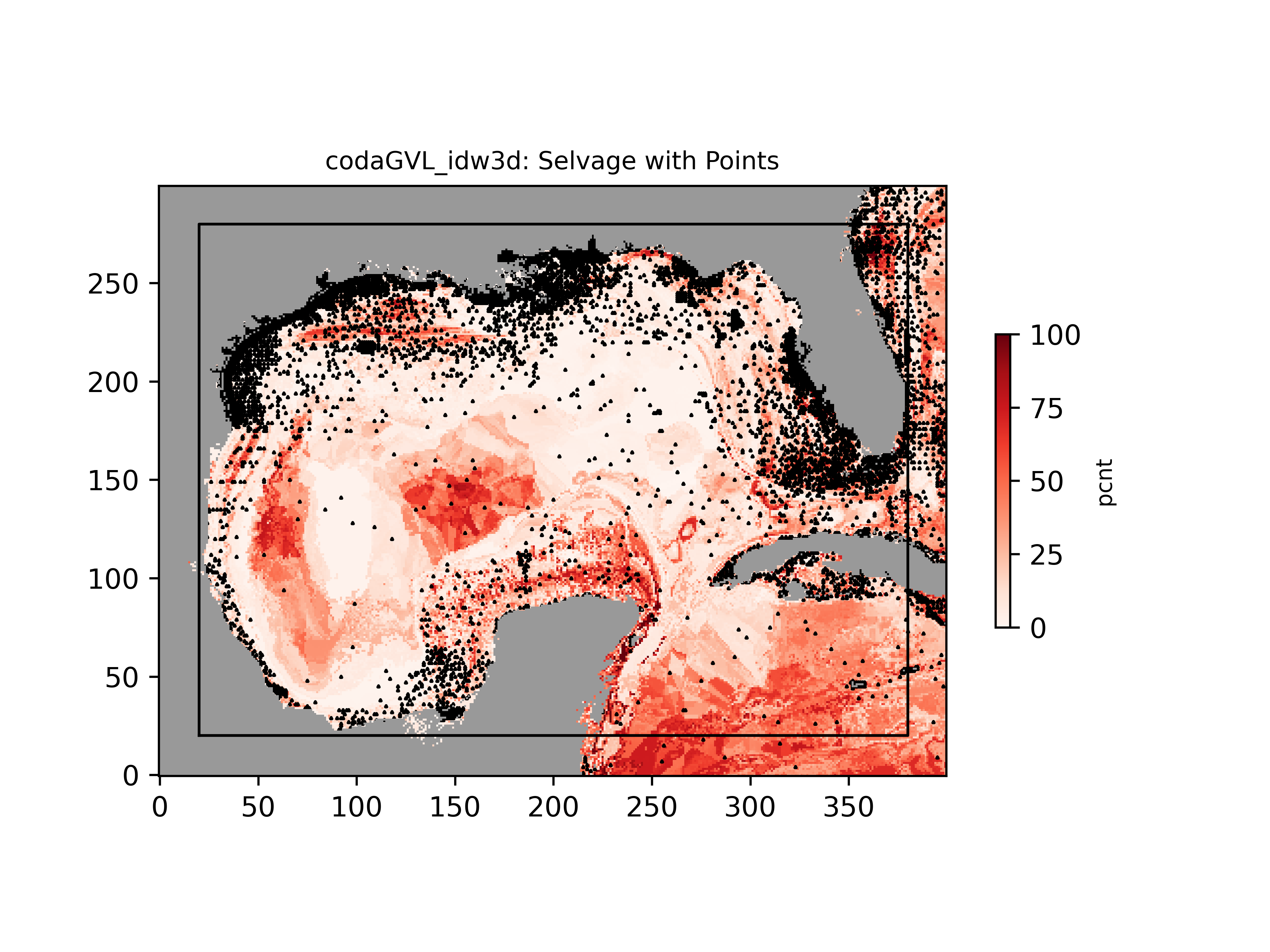 Spatial distribution of supporting data Spatial distribution of supporting data |
| Sand Fraction (%) - Surficial Seafloor, computed with Compositional Data (CODA) methods | https://csdms.colorado.edu/pub/data/dbSEABED/gomex_codaSND_idw3d.tif Gridded coverage of values | 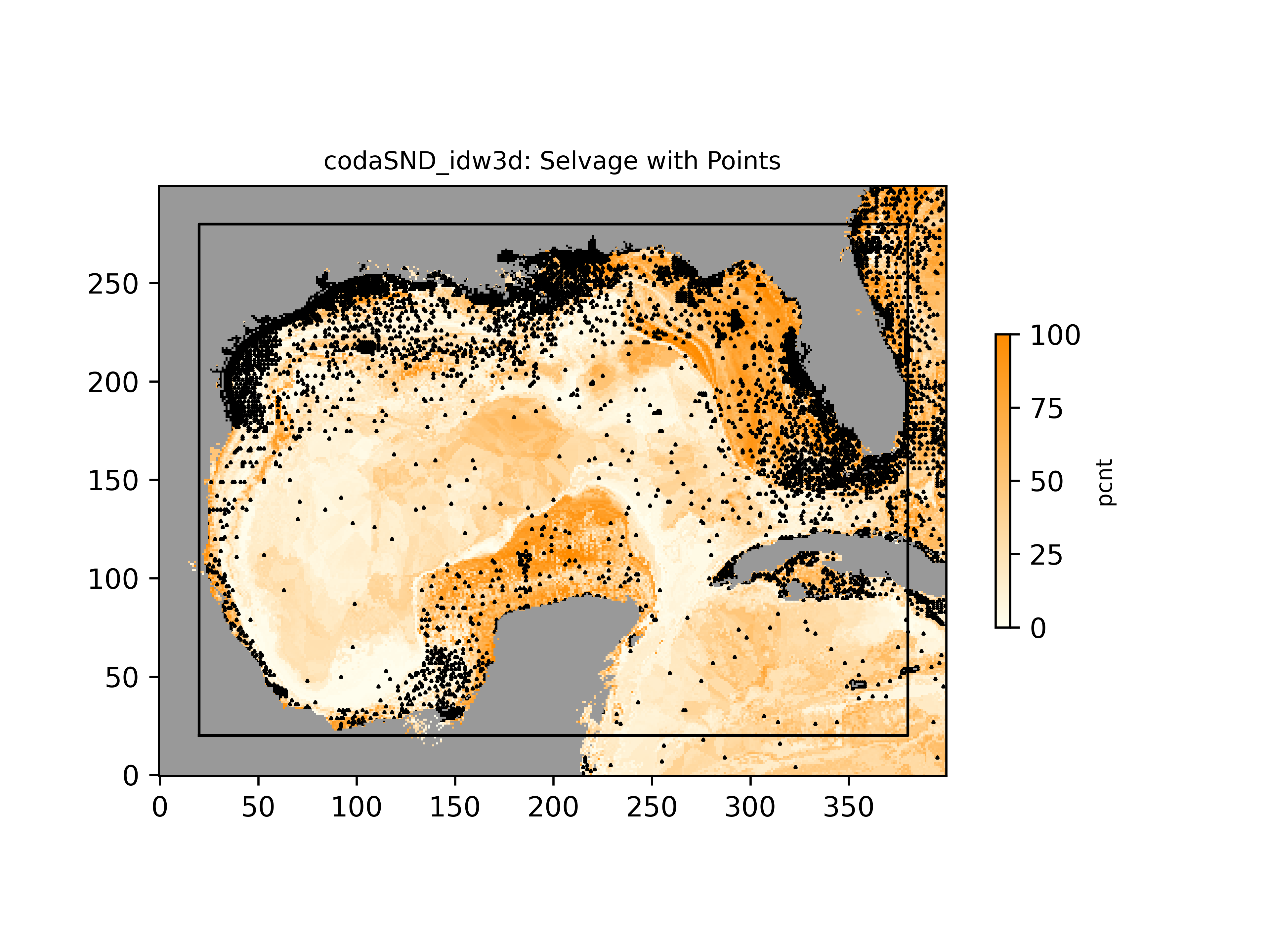 Spatial distribution of supporting data Spatial distribution of supporting data |
| Mud Fraction (%) - Surficial Seafloor, computed with Compositional Data (CODA) methods | https://csdms.colorado.edu/pub/data/dbSEABED/gomex_codaMUD_idw3d.tif Gridded coverage of values | 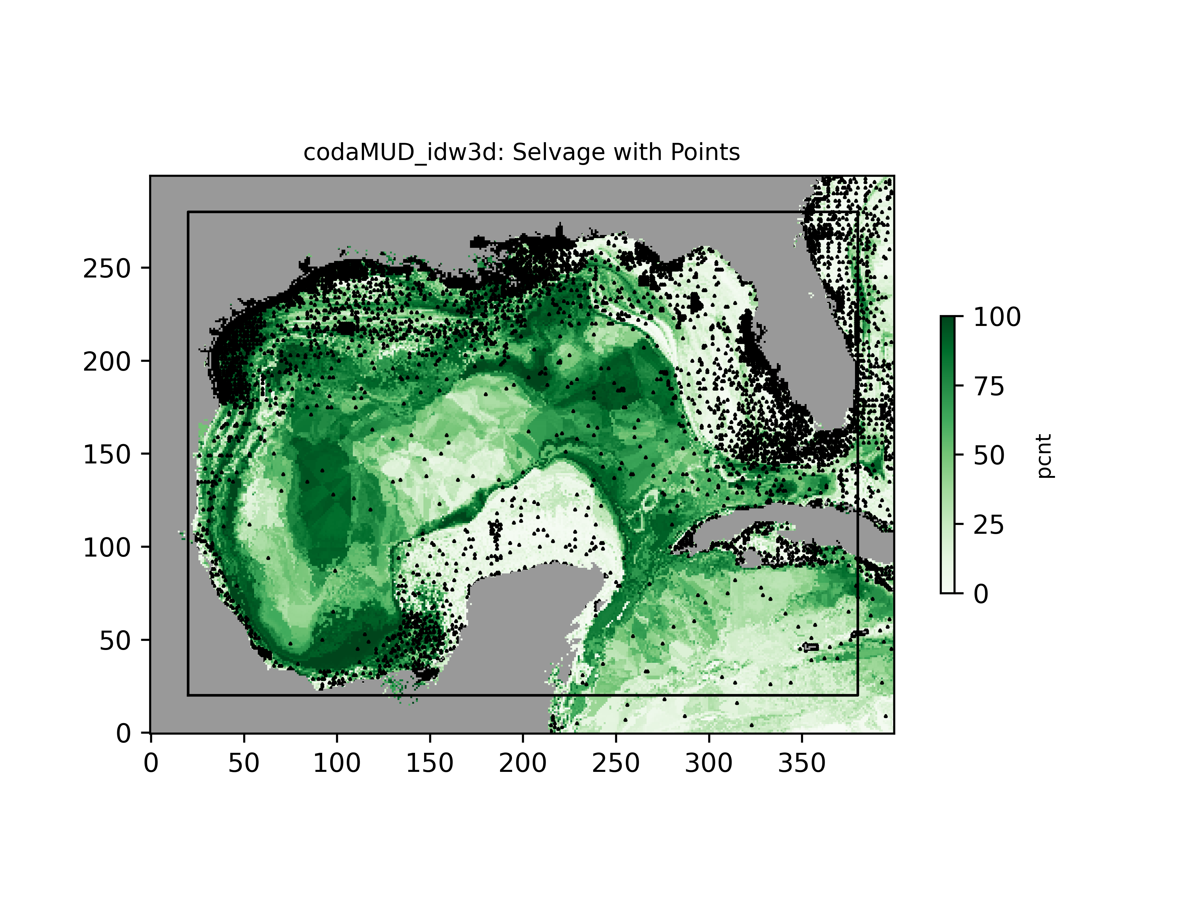 Spatial distribution of supporting data Spatial distribution of supporting data |
| Carbonate Content (%) - Surficial Seafloor | https://csdms.colorado.edu/pub/data/dbSEABED/gomex_crb_idw3d.tif Gridded coverage of values | 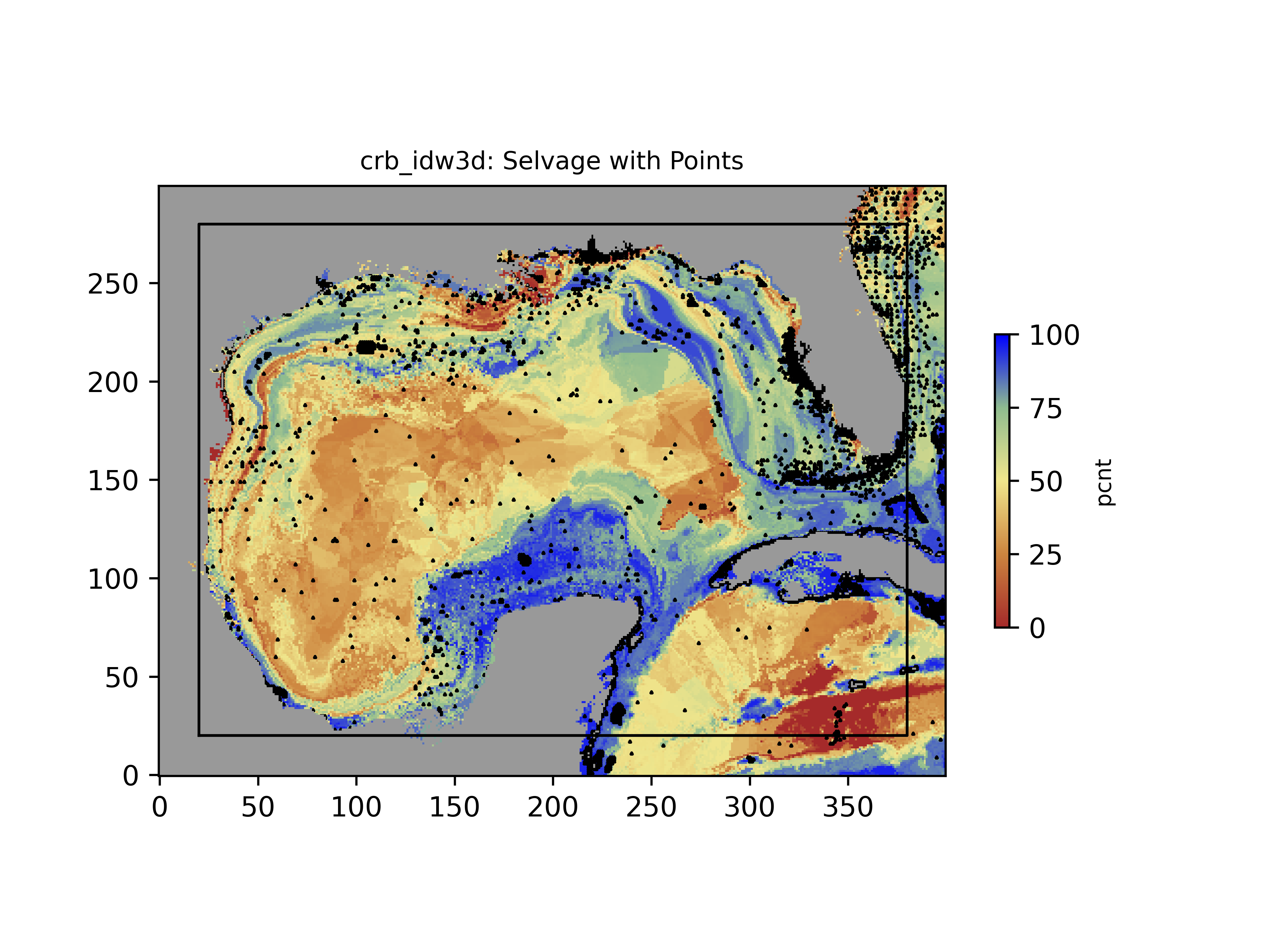 Spatial distribution of supporting data Spatial distribution of supporting data |
| Organic Carbon Content (%) - Surficial Seafloor | https://csdms.colorado.edu/pub/data/dbSEABED/gomex_ocbn_idw3d.tif Gridded coverage of values | 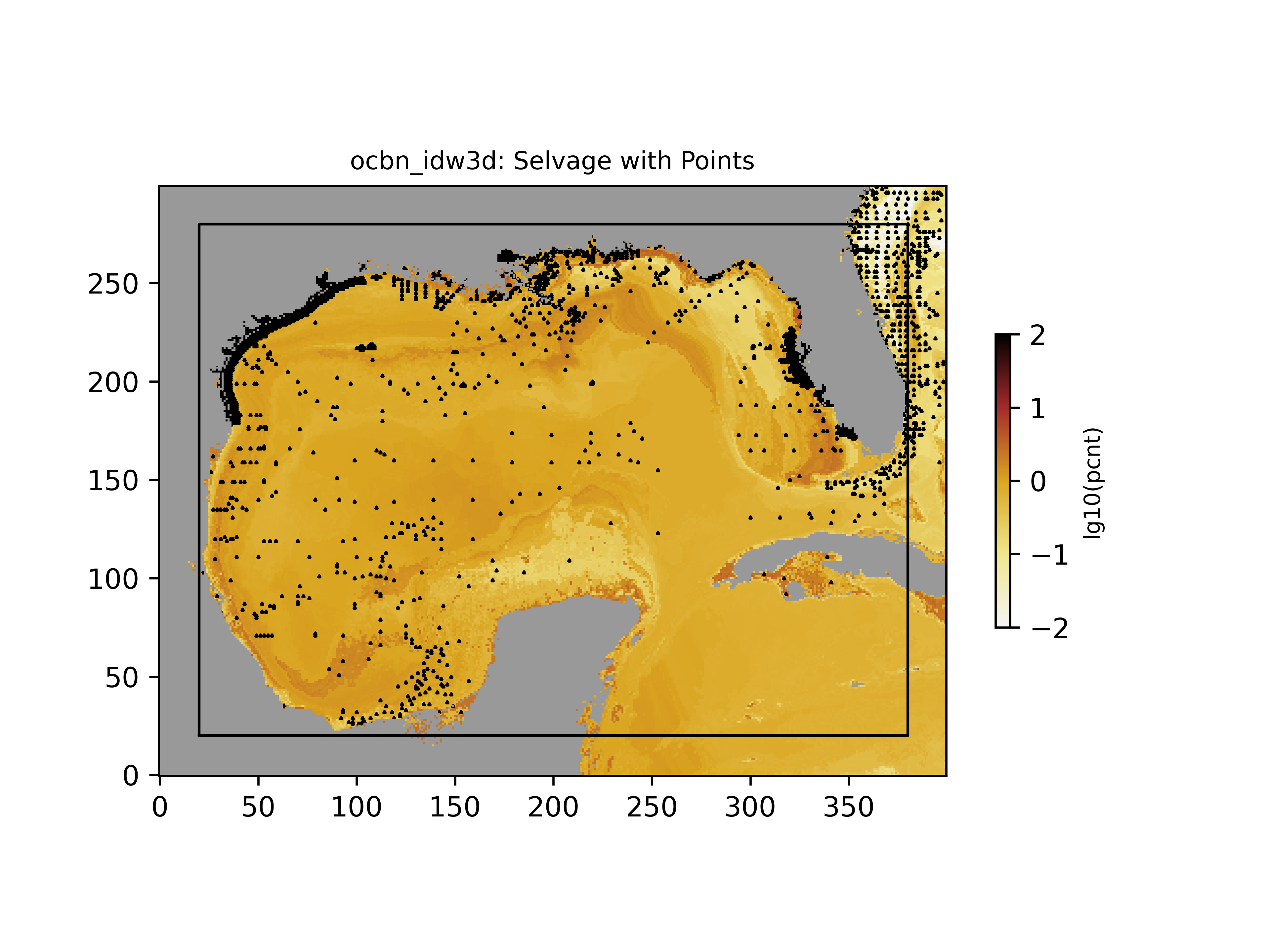 Spatial distribution of supporting data Spatial distribution of supporting data |
| Sediment Grainsize (phi) - Surficial Seafloor | https://csdms.colorado.edu/pub/data/dbSEABED/gomex_grz_idw3d.tif Gridded coverage of values |  Spatial distribution of supporting data Spatial distribution of supporting data |
| Exposed Rock Presence (%) - Surficial Seafloor | https://csdms.colorado.edu/pub/data/dbSEABED/gomex_rck_idw3d.tif Gridded coverage of values | 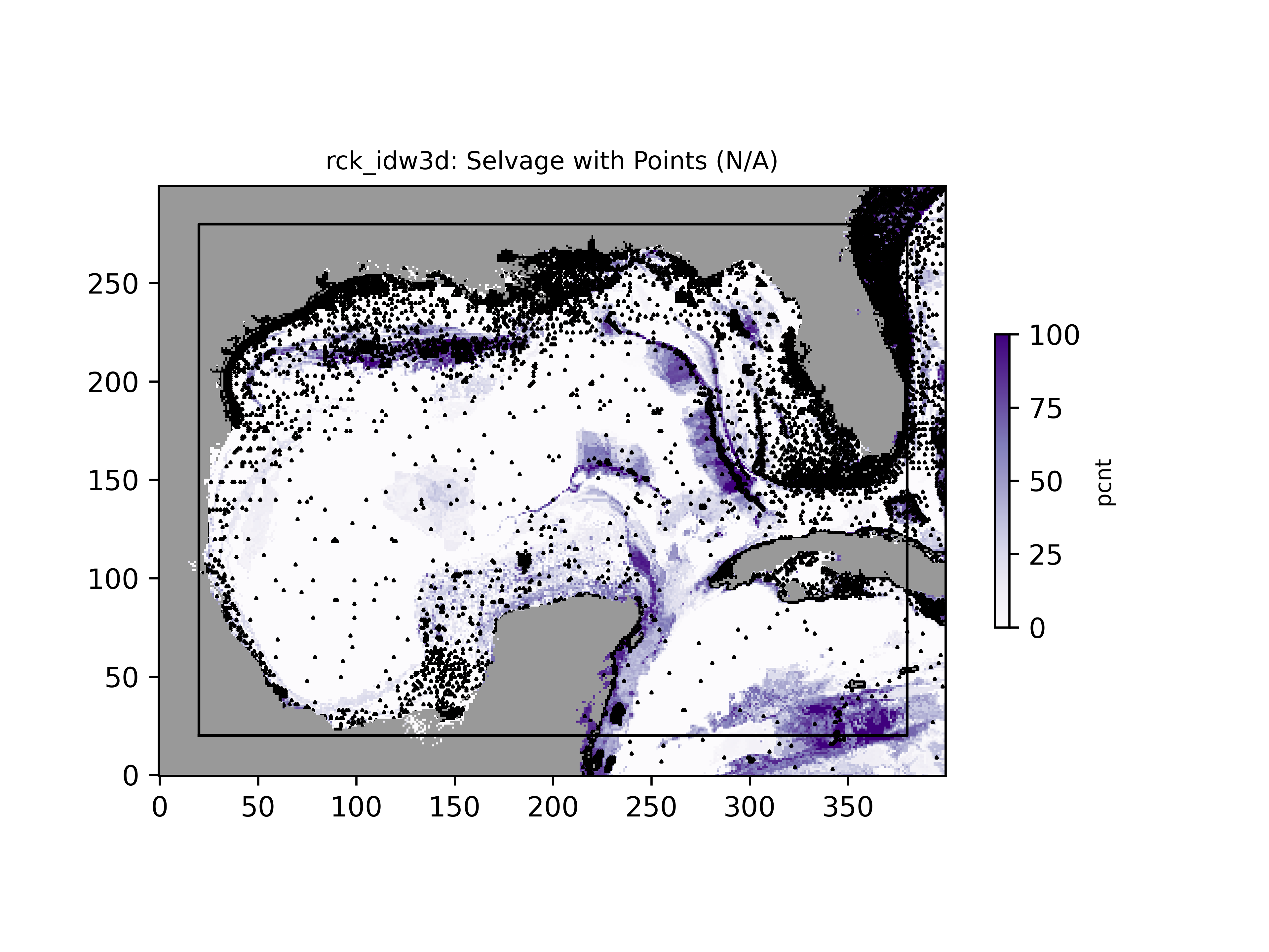 Spatial distribution of supporting data Spatial distribution of supporting data |
Data format
| Data type: | Substrates |
| Data origin: | Measured |
| Data format: | GeoTIFF |
| Other format: | github/bmi_dbseabed |
| Data resolution: | 0.05 deg |
| Datum: | WGS84 |
Data Coverage
Spatial data coverage: Gulf of Mexico
Temporal data coverage: Time averaged
Time period covered: 1960 - 2024
Availability
Download data: https://github.com/gantian127/bmi dbseabed
Data source: http://instaar.colorado.edu/~jenkinsc/dbseabed/
References
- Cite as: Jenkins, C.J. & Gan, T. 2024. Gulf of Mexico Seafloor Substrates. INSTAAR, University of Colorado, Boulder CO USA. (URL: "https://csdms.colorado.edu/wiki/Alldata:DBSEABED"; Last edit 27 June 2024)
