Annualmeeting:2017 CSDMS meeting-069
Browse abstracts
Global-Scale Event-Continuous Flood Event Simulation: When WBM Meets LISFLOOD-FP
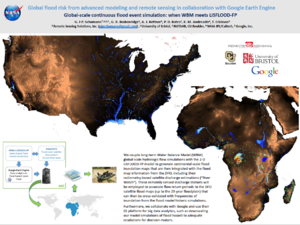
In an ongoing NASA project, our team is producing enhanced global flood hazard maps from advanced modeling, remote sensing and big data analytics. The innovation is that we couple long-term Water Balance Model (WBM) global scale hydrologic flow simulations with the 2-D LISFLOOD-FP model to generate continental scale flood inundation maps that are then integrated with the flood map information from the DFO, including their radiometry-based satellite discharge estimations, i.e. “River Watch”. These remotely sensed discharge stations will be employed to associate flow return periods to the DFO satellite flood maps (up to the 25-year floodplain) that can then be cross-validated with frequencies of inundation from the flood model historic simulations. Furthermore, we collaborate with Google Inc and use their EE platform for big data analytics, such as downscaling our model simulations of flood hazard to adequate resolutions for decision-makers. This poster will present first achievements for Australia, Africa and CONUS, and discuss challenges and perspectives.
