Annualmeeting:2017 CSDMS meeting-017
Browse abstracts
Resilience Analysis of Bangladesh Inland Waterway Network Using Landsat Data
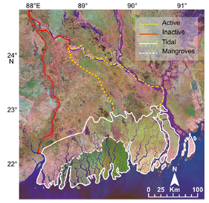
[[Image:|300px|right|link=File:]]The Ganges-Brahmaputra-Meghna Delta (GBMD), located in South Asia, is the largest river deltaic system in the world covering 41,000 mi2. Roughly the size of Kentucky, the GBMD is an extremely fertile region of protected mangrove forests and intensely cultivated land connected in a complex network of tidal channels, creeks, swamps, and oxbow lakes. Anthropogenic forces, natural subsidence accumulation, and eustatic sea level rise threaten deltas such as the GBMD and the quality of life of the people residing there. Most of the GBMD is located within Bangladesh and provides essential transportation services through inland waterways that carries 50% of cargo traffic and 25% of all passenger traffic mostly through the active northeastern region labeled with a dashed yellow line as shown in Figure 1. Vanderbilt’s multidisciplinary Integrated, Social, Environmental, and Engineering (ISEE) research team’s previous research efforts in Bangladesh focused on the physical characteristics of the deltaic system as climate change and anthropogenic forces affect it, but little is known about how channel closures affects the transportation network. Recent research has made use of available Landsat data combined with Google earth imagery to identify key metrics and attributes of the GBMD in order to link connectivity of distributary fluvial patterns to ecosystem services (Passalacqua et al., 2013). This work aims to integrate previous research using satellite imaging to model the transportation network that uses metrics such as channel width and nearest edge distance combined with available data on freight movement provided by multiple sources of information, such as the World Bank. In later stages of the project, we will use historical data of satellite imagery to capture channel dynamics that will be used to simulate disruptions to the transportation network and analyze subsequent impacts to Bangladesh’s economy. This allows decision makers to better understand how natural and anthropogenic forces affect the coupled human-environment system and to identify critical links within the transportation network that have the largest impact to Bangladesh’s economy when disrupted.
Reference: Passalacqua, Paola, et al. "Geomorphic signatures of deltaic processes and vegetation: The Ganges‐Brahmaputra‐Jamuna case study." Journal of Geophysical Research: Earth Surface 118.3 (2013): 1838-1849.

