Template:TEXT BOX LEFT: Difference between revisions
From CSDMS
No edit summary |
No edit summary |
||
| Line 1: | Line 1: | ||
[[image: | [[image:SPARROWMississippiP_delivery.png|200px|left|link=Model_highlight#SPARROW]] '''SPARROW''' – surface water quality model<br>SPARROW - SPAtially Referenced Regression on Watershed attributes – is a model for surface water quality of US river basins. USGS scientists Richard Alexander and Stephen Preston are the main developers, they support other research teams using SPARROW for regional water management and making predictions of coastal zone eutrophication. SPARROW uses spatial data of land-use, soil characteristics and climate, and ingests data on fertilizers, and point-source pollution to predict water and constituents fluxes over time.<br>[[Model_highlight#SPARRO|More...]]<br><br>[mailto:csdmsweb@colorado.edu Nominate a model] | ||
[[Model_highlight# | |||
Revision as of 15:43, 22 November 2011
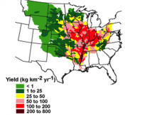
SPARROW – surface water quality model
SPARROW - SPAtially Referenced Regression on Watershed attributes – is a model for surface water quality of US river basins. USGS scientists Richard Alexander and Stephen Preston are the main developers, they support other research teams using SPARROW for regional water management and making predictions of coastal zone eutrophication. SPARROW uses spatial data of land-use, soil characteristics and climate, and ingests data on fertilizers, and point-source pollution to predict water and constituents fluxes over time.
More...
Nominate a model
