Template:TEXT BOX LEFT: Difference between revisions
No edit summary |
mNo edit summary |
||
| Line 1: | Line 1: | ||
[[image:TopoFlow_example.png|200px|left|link=Model_highlight#TopoFlow,_a_spatially-distributed_hydrologic_model]] | [[image:TopoFlow_example.png|200px|left|link=Model_highlight#TopoFlow,_a_spatially-distributed_hydrologic_model]] | ||
'''TopoFlow''' | '''TopoFlow''' mainly developed by Scott Peckham, is a 2D spatially-distributed hydrologic model that simulates different physical processes in a watershed with the goal of predicting how various hydrological variables like: snowmelt, precipitation, evapotranspiration, infiltration, channel/overland flow, shallow subsurface flow and flow diversions; response to climatic forcings. Time evolutions for single pixels (like hydrographs), collections of user-selected pixels, or entire grids (as animations) are all supported as output options. | ||
TopoFlow became available in 2010 as a set of over 20 plug and play components that can be used with the CSDMS Modeling Tool (CMT). | TopoFlow 3.0 became available in 2010 as a set of over 20 plug and play components that can be used with the CSDMS Modeling Tool (CMT). The components, can be either run as standalone or linked, and have successfully been linked to other models like a valley glacier model, GC2D.<br>[[Model_highlight#TopoFlow,_a_spatially-distributed_hydrologic_model|More...]]<br>[mailto:csdmsweb@colorado.edu Nominate a model] | ||
Revision as of 17:15, 23 November 2010
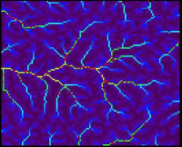
TopoFlow mainly developed by Scott Peckham, is a 2D spatially-distributed hydrologic model that simulates different physical processes in a watershed with the goal of predicting how various hydrological variables like: snowmelt, precipitation, evapotranspiration, infiltration, channel/overland flow, shallow subsurface flow and flow diversions; response to climatic forcings. Time evolutions for single pixels (like hydrographs), collections of user-selected pixels, or entire grids (as animations) are all supported as output options.
TopoFlow 3.0 became available in 2010 as a set of over 20 plug and play components that can be used with the CSDMS Modeling Tool (CMT). The components, can be either run as standalone or linked, and have successfully been linked to other models like a valley glacier model, GC2D.
More...
Nominate a model
