Template:TEXT BOX LEFT: Difference between revisions
mNo edit summary |
mNo edit summary |
||
| Line 1: | Line 1: | ||
[[image:TopoFlow_example.png|200px|left|link=]] | [[image:TopoFlow_example.png|200px|left|link=]] | ||
TopoFlow 3.0 is a 2D spatially-distributed hydrologic model | TopoFlow 3.0, mainly developed by Scott Peckham, is a 2D spatially-distributed hydrologic model that simulates different physical processes in a watershed with the goal of predicting how various hydrological variables, like snowmelt, precipitation, evapotranspiration, infiltration, channel/overland flow, shallow subsurface flow and flow diversions evolve in time in response to climatic forcings. Time evolutions for single pixels (like hydrographs), collections of user-selected pixels, or entire grids (as animations) are all supported as output options. | ||
TopoFlow became available in 2010 as a set of over 20 components that can be used with the CSDMS Modeling Tool (CMT). The components have successfully be linked to other models like a valley glacier model, GC2D.<br>[[Model highlight|More...]]<br>[mailto:csdmsweb@colorado.edu Nominate a model] | |||
Revision as of 15:56, 23 November 2010
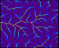
TopoFlow 3.0, mainly developed by Scott Peckham, is a 2D spatially-distributed hydrologic model that simulates different physical processes in a watershed with the goal of predicting how various hydrological variables, like snowmelt, precipitation, evapotranspiration, infiltration, channel/overland flow, shallow subsurface flow and flow diversions evolve in time in response to climatic forcings. Time evolutions for single pixels (like hydrographs), collections of user-selected pixels, or entire grids (as animations) are all supported as output options.
TopoFlow became available in 2010 as a set of over 20 components that can be used with the CSDMS Modeling Tool (CMT). The components have successfully be linked to other models like a valley glacier model, GC2D.
More...
Nominate a model
