File:Topography.png
From CSDMS
No higher resolution available.
Topography.png (399 × 278 pixels, file size: 99 KB, MIME type: image/png)
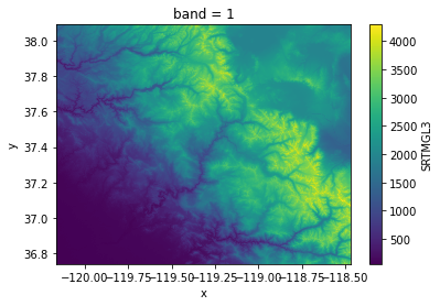
An example of visualizing land elevation data downloaded with the Topography data component.
File history
Click on a date/time to view the file as it appeared at that time.
| Date/Time | Thumbnail | Dimensions | User | Comment | ||
|---|---|---|---|---|---|---|
| delete all | current | 12:40, 20 December 2021 | | 399 × 278 (99 KB) | Mpiper (talk | contribs) | An example of visualizing land elevation data downloaded with the Topography data component. |
You cannot overwrite this file.
File usage
The following page uses this file:
