Alldata:Southern Alaska Coastal Relief Model: Difference between revisions
Created page with '{{Data description |One-line data description=A digital elevation model for Southern Alaska |Extended data description=The Southern Alaska Coastal Relief Model is a 24 arc-second…' |
m WikiSysop moved page Data:Southern Alaska Coastal Relief Model to Alldata:Southern Alaska Coastal Relief Model without leaving a redirect |
||
| (5 intermediate revisions by 3 users not shown) | |||
| Line 1: | Line 1: | ||
{{Data description | {{Data description | ||
|One-line data description= | |One-line data description=Integrated bathymetric-topographic relief model of Southern Alaska; 24 arc-second cell size | ||
|Extended data description=The Southern Alaska Coastal Relief Model is a 24 arc-second digital elevation model ranging from 170° to 230° and 48.5° to 66.5° N. It integrates bathymetry and topography to represent Earth's surface and spans over the Gulf of Alaska, Bering Sea, Aleutian Islands, and Alaska's largest communities: Anchorage, Fairbanks, and Juneau. The relief model was built from a variety of source datasets acquired from the National Geophysical Data Center, National Ocean Service, United States Geological Survey, National Aeronautics and Space Administration, and other U.S. and international agencies. | |Extended data description=The Southern Alaska Coastal Relief Model is a 24 arc-second digital elevation model ranging from 170° to 230° and 48.5° to 66.5° N. It integrates bathymetry and topography to represent Earth's surface and spans over the Gulf of Alaska, Bering Sea, Aleutian Islands, and Alaska's largest communities: Anchorage, Fairbanks, and Juneau. The relief model was built from a variety of source datasets acquired from the National Geophysical Data Center, National Ocean Service, United States Geological Survey, National Aeronautics and Space Administration, and other U.S. and international agencies. | ||
The CRM provides a framework to enable scientists to model tsunami propagation and ocean circulation. In addition, it may be useful for benthic habitat research, weather forecasting, and environmental stewardship. | The CRM provides a framework to enable scientists to model tsunami propagation and ocean circulation. In addition, it may be useful for benthic habitat research, weather forecasting, and environmental stewardship. | ||
|Upload image dataset=Southern Alaska Coastal Relief Model.png | |Upload image dataset=Southern Alaska Coastal Relief Model.png | ||
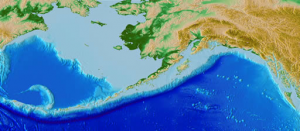
|Caption dataset image= | |Caption dataset image=Color hillshade of the So AK CRM | ||
}} | }} | ||
{{Data format | {{Data format | ||
|Data type=Topography | |Data type=Topography | ||
|Data origin=Modeled | |||
|Data format=GeoTIFF, NetCDF, Binary, ASCII | |Data format=GeoTIFF, NetCDF, Binary, ASCII | ||
|Data resolution=24 arc-second | |Data resolution=24 arc-second cell size | ||
|Data projection=WGS 84 geographic (horizontal); sea level (vertical) | |||
}} | }} | ||
{{Dataset coverage | {{Dataset coverage | ||
|Data spatial coverage=Southern Alaska (170° to 230° and 48.5° to 66.5° N) | |Data spatial coverage=Southern Alaska (170° to 230° and 48.5° to 66.5° N) | ||
|Data temporal coverage=Time | |Data temporal coverage=Time averaged | ||
}} | }} | ||
{{Dataset availability | {{Dataset availability | ||
|Data download link= | |Data download link=https://www.ncei.noaa.gov/products/coastal-relief-model | ||
|Data source link= | |Data source link=https://www.ncei.noaa.gov/products/coastal-relief-model | ||
}} | }} | ||
{{Data references | {{Data references | ||
|Key references dataset=Lim, E., B.W. Eakins, and R. Wigley, Coastal Relief Model of Southern Alaska, National Geophysical Data Center, NESDIS, NOAA, 2009. | |Key references dataset=Lim, E., B.W. Eakins, and R. Wigley, Coastal Relief Model of Southern Alaska, National Geophysical Data Center, NESDIS, NOAA, 2009. | ||
}} | }} | ||
Latest revision as of 10:48, 11 March 2025
Southern Alaska Coastal Relief Model dataset information page
Short Description
 |
| Color hillshade of the So AK CRM |
Statement: Integrated bathymetric-topographic relief model of Southern Alaska; 24 arc-second cell size
Abstract: The Southern Alaska Coastal Relief Model is a 24 arc-second digital elevation model ranging from 170° to 230° and 48.5° to 66.5° N. It integrates bathymetry and topography to represent Earth's surface and spans over the Gulf of Alaska, Bering Sea, Aleutian Islands, and Alaska's largest communities: Anchorage, Fairbanks, and Juneau. The relief model was built from a variety of source datasets acquired from the National Geophysical Data Center, National Ocean Service, United States Geological Survey, National Aeronautics and Space Administration, and other U.S. and international agencies.
The CRM provides a framework to enable scientists to model tsunami propagation and ocean circulation. In addition, it may be useful for benthic habitat research, weather forecasting, and environmental stewardship.
Data format
| Data type: | Topography |
| Data origin: | Modeled |
| Data format: | GeoTIFF, NetCDF, Binary, ASCII |
| Other format: | |
| Data resolution: | 24 arc-second cell size |
| Datum: | WGS 84 geographic (horizontal); sea level (vertical) |
Data Coverage
Spatial data coverage: Southern Alaska (170° to 230° and 48.5° to 66.5° N)
Temporal data coverage: Time averaged
Time period covered:
Availability
Download data: https://www.ncei.noaa.gov/products/coastal-relief-model
Data source: https://www.ncei.noaa.gov/products/coastal-relief-model
References
- Lim, E., B.W. Eakins, and R. Wigley, Coastal Relief Model of Southern Alaska, National Geophysical Data Center, NESDIS, NOAA, 2009.
