Data:NRLP India
NRLP India dataset information page
Short Description
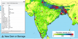
| Example of dam specs from the dams database |
Statement: Proposed canals and dams data for the Indian Rivers Interlinking project
Abstract: The Indian National River Linking Project (NRLP), or Indian Rivers Interlinking project (IRI), proposes a major redistribution of water resources over the Indian subcontinent. A large engineering effort is proposed to redistribute monsoonal water from the Himalayas and foothills, store water in reservoirs, and route it via canals ("links") to the drier regions of Southern India. A total of 29 links and 43 dams and barrages are proposed as part of the project. The plan would provide water resources for agriculture, drinking water and industrial use to a growing population in central and southern India, while potentially improving flood control in the northern and mountainous areas. The project would also result in a major reorganization of watersheds, with possible impacts on ecosystems and the environment. There would be impacts on trans-boundary rivers.
Here provided are two databases: (1) the dams database, with locations, operating specifications, sources, and notes on population expected to be displaced; and (2) the canals database, with locations, operating specifications, and further notes. The databases are available as shapefiles for GIS visualization - click a feature to see its database information. A "rivers" shapefile is also available for help in generating visualizations. Note that the rivers are not currently labeled in the shapefile. Raw txt/csv format is also available for the canals and dams databases. An annotated reference list is included to give specifics on the sources from which each number was obtained and/or calculated.
The databases are constructed from hundreds of government reports, geo-referenced maps, planning and design documents and Open Street Map data. For full methodology and calculations regarding displaced populations, see the accompanying manuscript: Higgins et al., 2017. For the graph database tool used to calculate basin connectivity changes and water discharge changes for given river mouths, see the github page: https://github.com/sahiggin/NRLP .
Data format
| Data type: | River discharge |
| Data origin: | Modeled |
| Data format: | Shapefile, CSV |
| Other format: | |
| Data resolution: | n/a |
| Datum: | October 2016 |
Data Coverage
Spatial data coverage: India, Nepal, China, Bangladesh
Temporal data coverage: Time snap shot
Time period covered: this is a design scheme, future
Availability
Download data: https://csdms.colorado.edu/pub/data/NRLP/NRLP.zip
Data source: https://csdms.colorado.edu/pub/data/NRLP/NRLP.zip
References
- India plans the grandest of canal networks
Pallava Bagla1 Science 11 Jul 2014: Vol. 345, Issue 6193, pp. 128 DOI: 10.1126/science.345.6193.128

