Data:NGDC Coastal Relief Model: Difference between revisions
No edit summary |
No edit summary |
||
| Line 1: | Line 1: | ||
{{Data description | {{Data description | ||
|One-line data description= | |One-line data description=Integrated bathymetric-topographic relief models of U.S. coasts; 3 arc-second (~90 m) cell size | ||
|Extended data description= | |Extended data description=The 3 arc-second U.S. Coastal Relief Model (CRM) provides the first comprehensive view of the U.S. coastal zone, integrating offshore bathymetry with land topography into a seamless representation of the coast. The CRM spans the U.S. East and West Coasts, the northern coast of the Gulf of Mexico, Puerto Rico, and Hawaii, reaching out to, and in places even beyond, the continental slope. | ||
Bathymetric data sources include the | Bathymetric data sources include the U.S. National Ocean Service Hydrographic Database, the U.S. Geological Survey (USGS), the Monterey Bay Aquarium Research Institute, the U.S. Army Corps of Engineers, and various other academic institutions. Topographic data are from the USGS and the Shuttle Radar Topography Mission (SRTM). Volumes 3 through 5 also use bathymetric contours from the International Bathymetric Chart of the Caribbean Sea and the Gulf of Mexico project. | ||
|Upload image dataset=NGDC Coastal Relief Model.png | |Upload image dataset=NGDC Coastal Relief Model.png | ||
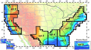
|Caption dataset image= | |Caption dataset image=Coverage of the U.S. CRM | ||
}} | }} | ||
{{Data format | {{Data format | ||
|Data type=Topography | |Data type=Topography | ||
|Data origin=Modeled | |Data origin=Modeled | ||
|Data format= | |Data format=NetCDF, Binary, ASCII | ||
|Other data format= | |Other data format=Arc ASCII | ||
|Data resolution=3 | |Data resolution=3 arc-second (~90 m) cell size (horizontal); 0.1 m (vertical) | ||
|Data projection=NAD 83 geographic (horizontal); sea level (vertical) | |||
}} | }} | ||
{{Dataset coverage | {{Dataset coverage | ||
|Data spatial coverage=conterminous | |Data spatial coverage=conterminous U.S. coasts, Hawaii and Puerto Rico | ||
|Data temporal coverage=Time | |Data temporal coverage=Time averaged | ||
}} | }} | ||
{{Dataset availability | {{Dataset availability | ||
| Line 25: | Line 24: | ||
}} | }} | ||
{{Data references | {{Data references | ||
|Key references dataset= | |Key references dataset=NOAA National Geophysical Data Center, U.S. Coastal Relief Model, Retrieved date goes here, http://www.ngdc.noaa.gov/mgg/coastal/crm.html | ||
}} | }} | ||
Revision as of 11:02, 24 March 2013
NGDC Coastal Relief Model dataset information page
Short Description
| Coverage of the U.S. CRM |
Statement: Integrated bathymetric-topographic relief models of U.S. coasts; 3 arc-second (~90 m) cell size
Abstract: The 3 arc-second U.S. Coastal Relief Model (CRM) provides the first comprehensive view of the U.S. coastal zone, integrating offshore bathymetry with land topography into a seamless representation of the coast. The CRM spans the U.S. East and West Coasts, the northern coast of the Gulf of Mexico, Puerto Rico, and Hawaii, reaching out to, and in places even beyond, the continental slope.
Bathymetric data sources include the U.S. National Ocean Service Hydrographic Database, the U.S. Geological Survey (USGS), the Monterey Bay Aquarium Research Institute, the U.S. Army Corps of Engineers, and various other academic institutions. Topographic data are from the USGS and the Shuttle Radar Topography Mission (SRTM). Volumes 3 through 5 also use bathymetric contours from the International Bathymetric Chart of the Caribbean Sea and the Gulf of Mexico project.
Data format
| Data type: | Topography |
| Data origin: | Modeled |
| Data format: | NetCDF, Binary, ASCII |
| Other format: | Arc ASCII |
| Data resolution: | 3 arc-second (~90 m) cell size (horizontal); 0.1 m (vertical) |
| Datum: | NAD 83 geographic (horizontal); sea level (vertical) |
Data Coverage
Spatial data coverage: conterminous U.S. coasts, Hawaii and Puerto Rico
Temporal data coverage: Time averaged
Time period covered:
Availability
Download data: http://www.ngdc.noaa.gov/mgg/coastal/crm.html
Data source: http://www.ngdc.noaa.gov/mgg/coastal/crm.html
References
- NOAA National Geophysical Data Center, U.S. Coastal Relief Model, Retrieved date goes here, http://www.ngdc.noaa.gov/mgg/coastal/crm.html

