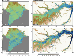
Alldata:MERIT DEM
From CSDMS
MERIT DEM dataset information page
Short Description
Statement: The MERIT DEM was developed by removing multiple error components from existing spaceborne DEMs (SRTM3 and AW3D)
Abstract: The MERIT DEM was developed by removing multiple error components (absolute bias, stripe noise, speckle noise, and tree height bias) from the existing spaceborne DEMs (SRTM3 and AW3D). It represents the terrain elevations at a 3sec resolution (~90m at the equator), and covers land areas between 90N-60S. The data is freely available for research and education purpose.
Data format
| Data type: | Topography |
| Data origin: | Measured |
| Data format: | GeoTIFF, BIL |
| Other format: | |
| Data resolution: | 3arc sec |
| Datum: | wgs84 |
Data Coverage
Spatial data coverage: global
Temporal data coverage: Time snap shot
Time period covered: ~2000s
Availability
Download data: http://hydro.iis.u-tokyo.ac.jp/~yamadai/MERIT DEM/
Data source: http://hydro.iis.u-tokyo.ac.jp/~yamadai/MERIT DEM/

