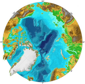
IBCAO dataset information page
Short Description
| IBCAO map of Technical User's guide |
Statement: International Bathymetric Chart of the Arctic Ocean (IBCAO)
Abstract: The goal of this initiative is to develop a digital data base that contains all available bathymetric data north of 64 degrees North, for use by mapmakers, researchers, and others whose work requires a detailed and accurate knowledge of the depth and the shape of the Arctic seabed. Version 2.0 of the IBCAO Grid is now available for downloading along with maps that are suitable for plotting. This new update is the most comprehensive since the first release of IBCAO in 2000 and includes the recent years of multibeam mapping. The resolution of the Polarstereographic grid has been increased from 2.5-km to 2-km. The compilation of IBCAO Version 2.0 is described in a Geophysical Research Letter article.
Data format
| Data type: | Topography |
| Data origin: | Modeled |
| Data format: | ArcExport, KMZ, NetCDF |
| Other format: | |
| Data resolution: | 2km |
| Datum: | Polar stereographic projection |
Data Coverage
Spatial data coverage: Bathymetric data North of 64 degrees North
Temporal data coverage: Time snap shot
Time period covered: 2008 (ongoing updates)
Availability
Download data: http://www.ngdc.noaa.gov/mgg/bathymetry/arctic/downloads.html
Data source: http://www.ngdc.noaa.gov/mgg/bathymetry/arctic/
References
- Jakobsson, M., Macnab, R., Mayer, L., Anderson, R., Edwards, M., Hatzky, J., Schenke, H-W., and Johnson, P., 2008, An improved bathymetric portrayal of the Arctic Ocean: Implications for ocean modeling and geological, geophysical and oceanographic analyses, v. 35, L07602, Geophysical Research Letters, doi:10.1029/2008GL033520

