Alldata:HYDAT
HYDAT dataset information page
Short Description
 |
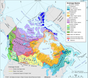
| Drainage basins of Canada |
Statement: HYDAT - Online access to historical water levels, streamflow and sediment data of Canada
Abstract: On-line access to information on historical (archived) water levels and streamflow. Using map-based or text-based searches, users can locate over 1200 hydrometric stations measuring water levels and view hydrographs of historical waer level and streamflow data. Alternatively, users can use a separate tool to select and access historical data from over 2500 active stations and 5500 discontinued stations. In addition, a third tool allows users to generate historical water level and/or streamflow statistics for any of these (more than) 8000 stations.
Data format
| Data type: | River discharge |
| Data origin: | Measured |
| Data format: | ASCII |
| Other format: | |
| Data resolution: | Point source data |
| Datum: |
Data Coverage
Spatial data coverage: Canada
Temporal data coverage: Time series
Time period covered:
Availability
Download data: https://wateroffice.ec.gc.ca/
Data source: https://wateroffice.ec.gc.ca/
