Alldata:Great Bay, NH - BBL Data June 2011
Great Bay, NH - BBL Data June 2011 dataset information page
Short Description
 |
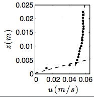
| Average velocity profile of tidal bottom boundary layer over lowest 2.5 cm of the water column. Dashed lines are regression lines. |
Statement: Fine resolution bottom boundary layer velocity measurements in a tidal estuary
Abstract: This data set provides acoustic measurements of the bottom boundary layer in a tidal current over flat muddy-sand bed. Observations made with Nortek Vectrino Profiler over the lowest 2.5 cm of the water column with a 1 mm resolution. Observations were made in June of 2011 just after slack tide during a flood tidal flow. Please contact Diane Foster of the University of New Hampshire with any questions (diane.foster@unh.edu).
References: Wengrove, M. E., & Foster, D. L. (2014). Field evidence of the viscous sublayer in a tidally forced developing boundary layer. Geophysical Research Letters, 41(14), 5084-5090.
Wengrove, M. E., Foster, D. L., Kalnejais, L. H., Percuoco, V., & Lippmann, T. C. (2015). Field and laboratory observations of bed stress and associated nutrient release in a tidal estuary. Estuarine, Coastal and Shelf Science, 161, 11-24.
Data format
| Data type: | Oceanography |
| Data origin: | Measured |
| Data format: | ASCII |
| Other format: | |
| Data resolution: | 1 mm over 2.5 cm |
| Datum: |
Data Coverage
Spatial data coverage: Single location
Temporal data coverage: Time series
Time period covered: Entire data set is 6 hours during flood tide, this limited subset is 15 minutes of slack tide
Availability
Download data: https://csdms.colorado.edu/pub/data/Great Bay NH-BBL/greatbay nh bbl june 2011.zip
Data source: https://csdms.colorado.edu/pub/data/Great Bay NH-BBL/greatbay nh bbl june 2011.zip
