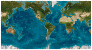
Alldata:GEBCO
GEBCO dataset information page
Short Description
 |
| GEBCO world map |
Statement: Global integrated bathymetric-topographic relief model; 1 arc-minute (~2 km) and 30 arc-second (~1 km) cell sizes
Abstract: General Bathymetric Chart of the Oceans (GEBCO). The GEBCO_08 Grid is a continuous terrain model (latest version - Sept 2011) for ocean and land with a spatial resolution of 30 arc-seconds. The bathymetry data were produced by combining the published Smith and Sandwell global topographic grid between latitudes 80°N and 81°S (version 11.1, September, 2008) with a database of over 290 million bathymetric soundings.
For the area north of Antarctica, the land data are based on the 1-km averages of topography derived from version 2.0 of the US Geological Survey SRTM30 gridded digital elevation model data product created with data from the US National Aeronautics and Space Administration (NASA) Shuttle Radar Topography Mission and, for high latitudes were SRTM data are not available, the US Geological Survey GTOPO30 data set.
For the area around Antarctica, the land data are taken from the Geoscience Laser Altimeter System (GLAS) instrument on the Ice, Cloud, and land Elevation Satellite (ICESat) laser altimetry digital elevation model.
The complete data sets give global coverage and each file consists of 21,600 rows x 43,200 columns, resulting in 9,331,200,000 data points. The data start at the Northwest corner of the files, i.e. for the global files, position 89° 59‟ 45‟‟N, 179° 59‟ 45‟‟W and are arranged in latitudinal bands of 360 degrees x 120 points/degree = 43,200 values. The data range eastward from 179° 59‟ 45‟‟W to 179° 59‟ 45‟‟E. Thus, the first band contains 43,200 values for 89° 59‟ 45‟‟N, then followed by a band of 43,200 values at 89°59‟ 15‟‟N and so on at 30 arc-second latitude intervals down to 89° 59‟ 45‟‟S.
Data format
| Data type: | Topography |
| Data origin: | Modeled |
| Data format: | NetCDF, ASCII |
| Other format: | |
| Data resolution: | 30 arc-second (~1 km) cell size |
| Datum: | WGS 84 geographic (horizontal); sea level (vertical) |
Data Coverage
Spatial data coverage: Global bathymetry
Temporal data coverage: Time snap shot
Time period covered: data incorporated till 2009 (dataset still updated)
Availability
Download data: https://www.bodc.ac.uk/data/online delivery/gebco/
Data source: http://www.gebco.net/
