Data:ETOPO1: Difference between revisions
From CSDMS
(Created page with '{{Data description |One-line data description=ETOPO1 is a 1 arc-minute global relief model |Caption dataset image=ETOPO1 Global Relief Model }} {{Data format |Data type=Topograph…') |
No edit summary |
||
| (13 intermediate revisions by 2 users not shown) | |||
| Line 1: | Line 1: | ||
{{Data description | {{Data description | ||
|One-line data description=ETOPO1 is a 1 arc-minute global relief model | |One-line data description=Global integrated bathymetric-topographic relief model; 1 arc-minute (~2 km) cell size | ||
|Extended data description=ETOPO1 is a 1 arc-minute global relief model of Earth's surface that integrates land topography and ocean bathymetry. It was built from numerous global and regional data sets, and is available in "Ice Surface" (top of Antarctic and Greenland ice sheets) and "Bedrock" (base of the ice sheets) versions. | |||
|Upload image dataset=ETOPO1.png | |||
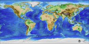
|Caption dataset image=ETOPO1 Global Relief Model | |Caption dataset image=ETOPO1 Global Relief Model | ||
}} | }} | ||
{{Data format | {{Data format | ||
|Data type=Topography | |Data type=Topography | ||
|Data format=GeoTIFF, NetCDF | |Data origin=Modeled | ||
|Data format=GeoTIFF, NetCDF, Binary, ASCII | |||
|Data resolution=1 arc-minute cell size (horizontal); 1 meter (vertical) | |||
|Data projection=WGS 84 geographic (horizontal); sea level (vertical) | |||
}} | }} | ||
{{Dataset coverage | {{Dataset coverage | ||
|Data spatial coverage=Global | |Data spatial coverage=Global | ||
|Data temporal coverage=Time | |Data temporal coverage=Time averaged | ||
}} | }} | ||
{{Dataset availability | {{Dataset availability | ||
|Data download link= | |Data download link=https://www.ncei.noaa.gov/products/etopo-global-relief-model | ||
|Data source link= | |Data source link=https://www.ncei.noaa.gov/products/etopo-global-relief-model | ||
}} | |||
{{Data references | |||
|Key references dataset=Amante, C. and B. W. Eakins, ETOPO1 1 Arc-Minute Global Relief Model: Procedures, Data Sources and Analysis. NOAA Technical Memorandum NESDIS NGDC-24, 19 pp, March 2009. | |||
}} | }} | ||
Latest revision as of 08:53, 19 January 2023
ETOPO1 dataset information page
Short Description
| ETOPO1 Global Relief Model |
Statement: Global integrated bathymetric-topographic relief model; 1 arc-minute (~2 km) cell size
Abstract: ETOPO1 is a 1 arc-minute global relief model of Earth's surface that integrates land topography and ocean bathymetry. It was built from numerous global and regional data sets, and is available in "Ice Surface" (top of Antarctic and Greenland ice sheets) and "Bedrock" (base of the ice sheets) versions.
Data format
| Data type: | Topography |
| Data origin: | Modeled |
| Data format: | GeoTIFF, NetCDF, Binary, ASCII |
| Other format: | |
| Data resolution: | 1 arc-minute cell size (horizontal); 1 meter (vertical) |
| Datum: | WGS 84 geographic (horizontal); sea level (vertical) |
Data Coverage
Spatial data coverage: Global
Temporal data coverage: Time averaged
Time period covered:
Availability
Download data: https://www.ncei.noaa.gov/products/etopo-global-relief-model
Data source: https://www.ncei.noaa.gov/products/etopo-global-relief-model
References
- Amante, C. and B. W. Eakins, ETOPO1 1 Arc-Minute Global Relief Model: Procedures, Data Sources and Analysis. NOAA Technical Memorandum NESDIS NGDC-24, 19 pp, March 2009.

