Data:DBSEABED: Difference between revisions
No edit summary |
No edit summary |
||
| Line 1: | Line 1: | ||
{{Data description | {{Data description | ||
|One-line data description=dbSEABED describes the materials and features of the global seafloor. | |One-line data description=dbSEABED describes the materials and features of the global seafloor. | ||
|Extended data description=dbSEABED is | |Extended data description=dbSEABED is a Database/GIS that deals with the materials and features of the seabed. It holds data describing about 2 million seafloor sites. dbSEABED deals with the grain size textures, strengths and porosities, carbon and carbonate compositions, colors, structural features, and grain components of the seafloor. | ||
The scope of dbSEABED is global, from shoreline and continental shelf to the abyssal floor, addressing terrigenous-, volcanic- and biogenic-derived materials in their rock and sediment forms. | |||
dbSEABED deals with the grain size textures, strengths and porosities, carbon and carbonate compositions, colors, structural features, and grain components of the seafloor | This site publishes gridded outputs suitable for use by numerical modellers. | ||
The scope of dbSEABED is | |||
|Upload image dataset=Adr mudT.jpg | |Upload image dataset=Adr mudT.jpg | ||
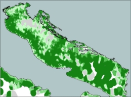
|Caption dataset image=Example data layer:<br> Mud areas | |Caption dataset image=Example data layer:<br> Mud areas of the Adriatic Seafloor. | ||
}} | }} | ||
{{Data format | {{Data format | ||
Revision as of 11:45, 2 March 2010
DBSEABED dataset information page
Short Description
| Example data layer: Mud areas of the Adriatic Seafloor. |
Statement: dbSEABED describes the materials and features of the global seafloor.
Abstract: dbSEABED is a Database/GIS that deals with the materials and features of the seabed. It holds data describing about 2 million seafloor sites. dbSEABED deals with the grain size textures, strengths and porosities, carbon and carbonate compositions, colors, structural features, and grain components of the seafloor. The scope of dbSEABED is global, from shoreline and continental shelf to the abyssal floor, addressing terrigenous-, volcanic- and biogenic-derived materials in their rock and sediment forms. This site publishes gridded outputs suitable for use by numerical modellers.
Data format
| Data type: | Substrates |
| Data origin: | Measured |
| Data format: | ASCII |
| Other format: | |
| Data resolution: | |
| Datum: |
Data Coverage
Spatial data coverage: Global point source measurements
Temporal data coverage: Time averaged
Time period covered:
Availability
Download data: http://csdms.colorado.edu/wiki/DBSEABED
Data source: http://instaar.colorado.edu/~jenkinsc/dbseabed/
References
- Cite: Jenkins, C.J. 2010. Seafloor Substrates. INSTAAR, University of Colorado, Boulder CO USA. (URL: "http://csdms.colorado.edu/wiki/DBSEABED"; Last edit 18 Feb 2010)

