CSDMS 2015 annual meeting poster StephanieHiggins
Potential impacts of Indian Rivers Inter-links on sediment transport to the Ganges-Brahmaputra Delta
Irina Overeem, University of Colorado Boulder, Colorado, United States.
James Syvitski, University of Colorado Boulder, Colorado, United States.
Abstract:
The Indian Rivers Inter-link project is a proposal to link several of India's major rivers via a network of reservoirs and canals. If the Inter-link project moves forward, fourteen canals will divert water from tributaries of the Ganges and Brahmaputra rivers to areas in the west, where fresh water is needed in cities and agricultural areas. Here, we investigate the impacts of the proposed diversions on sediment transport to the Ganges-Brahmaputra Delta, Bangladesh. Changing watersheds are delineated using the Terrain Analysis Using Digital Elevation Models (TauDEM) Suite, developed by David Tarboton. Climate data comes from interpolation between 30 observed precipitation stations located in China, Nepal, India, Bhutan and Bangladesh (Pervez & Henebry, 2014). Changes in water discharge due to the proposed canals are simulated using HydroTrend, a climate-driven hydrological water balance and transport model that incorporates drainage area, discharge, relief, temperature, basin-average lithology, and anthropogenic influences (Kettner & Syvitski, 2008). Simulated river discharge is validated against observations from the Farakka and Bahadurabad gauging stations, where the Ganges and Brahmaputra rivers respectively enter Bangladesh (Fig. 1). HydroTrend is then used to investigate sediment transport changes that may result from the proposed canals. Preliminary results show that sediment loads to the delta will be reduced at both locations. Additional canals may also transport Himalayan sediments 500 km south to the Mahanadi delta and more than 1000 km south to the Godavari and Krishna deltas in India.
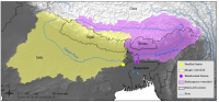
Watersheds of the Ganges (yellow) and Brahmaputra (purple) rivers without artificial diversions.
* Please acknowledge the original contributors when you are using this material. If there are any copyright issues, please let us know and we will respond as soon as possible.
