2018 CSDMS meeting-091: Difference between revisions
(Created page with "{{CSDMS meeting personal information template-2018 |CSDMS meeting first name=Richard |CSDMS meeting last name=Barnes |CSDMS meeting institute=UC Berkeley |CSDMS meeting city=B...") |
No edit summary |
||
| Line 37: | Line 37: | ||
Here, I present new, best-in-class algorithms which perform the foregoing. I explain how they are implemented in a high-performance, open source C++ library called RichDEM which is accessible to general practitioners via Python. This design is novel among terrain analysis software and I argue that it is necessary for moving the field forward in a way which allows for rapid scientific development and practitioner adoption. | Here, I present new, best-in-class algorithms which perform the foregoing. I explain how they are implemented in a high-performance, open source C++ library called RichDEM which is accessible to general practitioners via Python. This design is novel among terrain analysis software and I argue that it is necessary for moving the field forward in a way which allows for rapid scientific development and practitioner adoption. | ||
|CSDMS meeting posterPDF=Barnes_CSDMS_POSTER_May2018.pdf | |||
|CSDMS meeting posterPNG=Barnes_CSDMS_POSTER_May2018.png | |||
}} | }} | ||
{{blank line template}} | {{blank line template}} | ||
Latest revision as of 11:53, 25 July 2018
Log in (or create account for non-CSDMS members)
Forgot username? Search or email:CSDMSweb@colorado.edu
Browse abstracts
Efficient Parallel Algorithms For Terrain Analysis
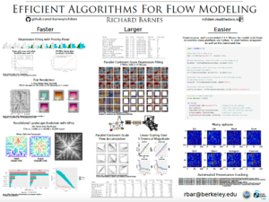
To answer geomorphological questions at unprecedented spatial and temporal scales, we need to (a) parse terabyte-scale datasets (DEMs), (b) perform millions of model realizations to pinpoint the parameters which govern landscape evolution, and (c) do so with statistical rigor, which may require thousands of additional realizations.
A core set of operations underpin many geomorphic models. These include determination of terrain attributes such as slope and curvature; flow routing; depression flooding and breaching; flat resolution; and flow accumulation.
Here, I present new, best-in-class algorithms which perform the foregoing. I explain how they are implemented in a high-performance, open source C++ library called RichDEM which is accessible to general practitioners via Python. This design is novel among terrain analysis software and I argue that it is necessary for moving the field forward in a way which allows for rapid scientific development and practitioner adoption.
