Log in (or create account for non-CSDMS members)
Forgot username? Search or email:CSDMSweb@colorado.edu
Browse abstracts
Integrating EO Data of Floods with a Hydrodynamic Event Model: Harvey 2017
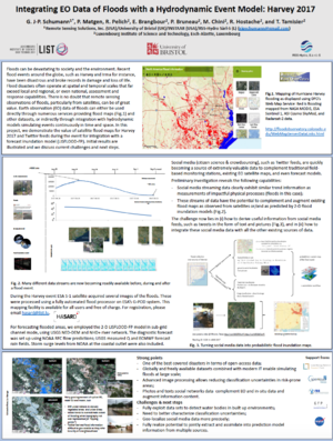
Floods can be devastating to society and the environment. Recent flood events around the globe, such as Harvey and Irma for instance, have been disastrous and broke records in damage and loss of life. Flood disasters often operate at spatial and temporal scales that far exceed local and regional, or even national, assessment and response capabilities. There is no doubt that remote sensing observations of floods, particularly from satellites, can be of great value. Earth observation (EO) data of floods can either be used directly through numerous services providing flood maps and other datasets, or indirectly through integration with hydrodynamic models simulating events continuously in time and space. In this project, we demonstrate the value of satellite flood maps for Harvey 2017 and Twitter feeds during the event for integration with a forecast inundation model (LISFLOOD-FP). Initial results are illustrated and we discuss current challenges and next steps.
 |
| This flood simulation is a 2-D LISFLOOD-FP simulation including river flows as well as direct rain on floodplain and a tidal-surge boundary. Whiter tones denote deeper flood waters. |
