2018 CSDMS meeting-007: Difference between revisions
Kerrylee37 (talk | contribs) (Created page with "{{CSDMS meeting personal information template-2018 |CSDMS meeting first name=Kerry |CSDMS meeting last name=Callaghan |CSDMS meeting institute=University of Minnesota |CSDMS m...") |
No edit summary |
||
| (3 intermediate revisions by one other user not shown) | |||
| Line 20: | Line 20: | ||
}} | }} | ||
{{CSDMS meeting select clinics3 2018 | {{CSDMS meeting select clinics3 2018 | ||
|CSDMS_meeting_select_clinics3_2018= | |CSDMS_meeting_select_clinics3_2018=1) Downscaling climate models for regional applications | ||
}} | }} | ||
{{CSDMS scholarships yes no | {{CSDMS scholarships yes no | ||
| Line 26: | Line 26: | ||
}} | }} | ||
{{CSDMS meeting abstract yes no 2018 | {{CSDMS meeting abstract yes no 2018 | ||
|CSDMS meeting abstract submit= | |CSDMS meeting abstract submit=Yes | ||
}} | |||
{{CSDMS meeting abstract title temp2018 | |||
|CSDMS meeting abstract title=Coupled groundwater and surface water modelling to visualise lake extent and total terrestrial water storage under a changing climate | |||
}} | |||
{{CSDMS meeting authors template | |||
|CSDMS meeting coauthor first name abstract=Andrew D | |||
|CSDMS meeting coauthor last name abstract=Wickert | |||
|CSDMS meeting coauthor institute / Organization=University of Minnesota | |||
|CSDMS meeting coauthor town-city=Minneapolis | |||
|CSDMS meeting coauthor country=United States | |||
|State=Minnesota | |||
|CSDMS meeting coauthor email address=awickert@umn.edu | |||
}} | |||
{{CSDMS meeting authors template | |||
|CSDMS meeting coauthor first name abstract=Ying Fan | |||
|CSDMS meeting coauthor last name abstract=Reinfelder | |||
|CSDMS meeting coauthor institute / Organization=Rutgers University | |||
|CSDMS meeting coauthor town-city=New Brunswick | |||
|CSDMS meeting coauthor country=United States | |||
|State=New Jersey | |||
|CSDMS meeting coauthor email address=yingfan@eps.rutgers.edu | |||
}} | |||
{{CSDMS meeting authors template | |||
|CSDMS meeting coauthor first name abstract=Gonzalo | |||
|CSDMS meeting coauthor last name abstract=Miguez-Macho | |||
|CSDMS meeting coauthor institute / Organization=University of Santiago de Compostela | |||
|CSDMS meeting coauthor town-city=Santiago de Compostela | |||
|CSDMS meeting coauthor country=Spain | |||
|CSDMS meeting coauthor email address=gonzalo.miguez@usc.es | |||
}} | |||
{{CSDMS meeting abstract template 2018 | |||
|CSDMS meeting abstract=Large-scale flow-routing algorithms efficiently route water to the ocean, neglecting both inland basins that may be able to form lakes and changing groundwater storage. We add these elements of reality in a simplified and computationally-efficient way, combining groundwater and surface-water routing to simulate changing groundwater levels, surface-water flow pathways, and lake locations and extents through time. The groundwater component is based upon a linear-diffusive model for an unconfined aquifer developed by Reinfelder et al (2013), and surface water is routed through a simple downslope-flow algorithm that differs from most flow-routing algorithms in that it takes into account the elevation of the water surface, and not just the land surface. Our model requires as inputs topography, climatic data (P-ET and winter temperature), and an approximation of hydraulic conductivity based on topographic slope and mapped soils. The model outputs grids of depth to water table and thickness of surface water; the latter depicts any lakes that would form under the topographic and climatic conditions. The model can be run to equilibrium, or, if a starting depth to water table input is provided, for any user-selected length of time. Such solutions are transient only with respect to groundwater movement: surface-water flow is significantly faster, so it is always run to equilibrium. The model allows infiltration when surface water flows across cells that are not fully saturated in the groundwater, and it allows exfiltration and the formation of groundwater-fed lakes where convergent groundwater flow raises the water table above the land surface.<br>We show sample results from this model on a test area. Future work using this model will include global runs since the Last Glacial Maximum, with ground truthing possible using past lake shoreline data. Changing depth to water table plus the surface water storage computed using this model allows computation of changing terrestrial water storage volume through time. | |||
|CSDMS meeting posterPDF=Callaghan CSDMS POSTER May2018.pdf | |||
|CSDMS meeting posterPNG=Callaghan CSDMS POSTER May2018.png | |||
}} | }} | ||
{{blank line template}} | {{blank line template}} | ||
Latest revision as of 08:25, 27 May 2018
Log in (or create account for non-CSDMS members)
Forgot username? Search or email:CSDMSweb@colorado.edu
Browse abstracts
Coupled groundwater and surface water modelling to visualise lake extent and total terrestrial water storage under a changing climate
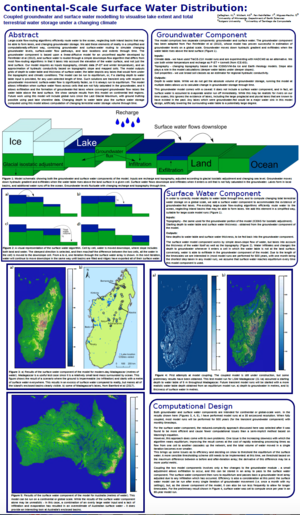
Large-scale flow-routing algorithms efficiently route water to the ocean, neglecting both inland basins that may be able to form lakes and changing groundwater storage. We add these elements of reality in a simplified and computationally-efficient way, combining groundwater and surface-water routing to simulate changing groundwater levels, surface-water flow pathways, and lake locations and extents through time. The groundwater component is based upon a linear-diffusive model for an unconfined aquifer developed by Reinfelder et al (2013), and surface water is routed through a simple downslope-flow algorithm that differs from most flow-routing algorithms in that it takes into account the elevation of the water surface, and not just the land surface. Our model requires as inputs topography, climatic data (P-ET and winter temperature), and an approximation of hydraulic conductivity based on topographic slope and mapped soils. The model outputs grids of depth to water table and thickness of surface water; the latter depicts any lakes that would form under the topographic and climatic conditions. The model can be run to equilibrium, or, if a starting depth to water table input is provided, for any user-selected length of time. Such solutions are transient only with respect to groundwater movement: surface-water flow is significantly faster, so it is always run to equilibrium. The model allows infiltration when surface water flows across cells that are not fully saturated in the groundwater, and it allows exfiltration and the formation of groundwater-fed lakes where convergent groundwater flow raises the water table above the land surface.
We show sample results from this model on a test area. Future work using this model will include global runs since the Last Glacial Maximum, with ground truthing possible using past lake shoreline data. Changing depth to water table plus the surface water storage computed using this model allows computation of changing terrestrial water storage volume through time.
