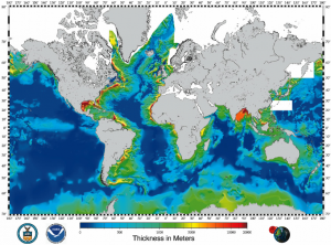
Alldata:Sediment Thickness of worlds oceans
Sediment Thickness of worlds oceans dataset information page
Short Description
 |
| Sediment tickness of the World's Oceans |
Statement: Total Sediment Thickness of the World's Oceans & Marginal Seas
Abstract: [[Extended data description::A digital total-sediment-thickness database for the world's oceans and marginal seas has been compiled by the NOAA National Geophysical Data Center (NGDC). The data were gridded with a grid spacing of 5 arc-minutes by 5 arc-minutes. Sediment-thickness data were compiled from three principle sources: (i) previously published isopach maps including Ludwig and Houtz [1979], Matthias et al. [1988], Divins and Rabinowitz [1990], Hayes and LaBrecque [1991], and Divins [2003]; (ii) ocean drilling results, both from the Ocean Drilling Program (ODP) and the Deep Sea Drilling Project (DSDP); and (iii) seismic reflection profiles archived at NGDC as well as seismic data and isopach maps available as part of the IOC's International Geological-Geophysical Atlas of the Pacific Ocean [Udinstev, 2003].
The distribution of sediments in the oceans is controlled by five primary factors:
- Age of the underlying crust
- Tectonic history of the ocean crust
- Structural trends in basement
- Nature and location of sediment source, and
- Nature of the sedimentary processes delivering sediments to depocenters
The sediment isopach contour maps for the Pacific were digitized by Greg Cole of Los Alamos National Laboratory, for the Indian Ocean by Carol Stein of Northwestern University, and the South Atlantic and Southern Ocean by Dennis Hayes of Lamont-Doherty Earth Observatory. The digitized data were then gridded at NGDC using the algorithm for "Gridding with Continuous Curvature Splines in Tension" of Smith and Wessel [1990].
The data values are in meters and represent the depth to acoustic basement. It should be noted that acoustic basement may not actually represent the base of the sediments. These data are intended to provide a minimum value for the thickness of the sediment in a particular geographic region.]]
Data format
| Data type: | Oceanography |
| Data origin: | Measured |
| Data format: | |
| Other format: | NetCDF |
| Data resolution: | Sediment thickness values represent an average over each 5-minute grid cell and are located at the center of each cell. |
| Datum: |
Data Coverage
Spatial data coverage: Ocean floor of the world
Temporal data coverage: Time averaged
Time period covered: --
Availability
Download data: http://www.ngdc.noaa.gov/mgg/sedthick/sedthick.html
Data source: http://www.ngdc.noaa.gov/mgg/sedthick/sedthick.html
References
- Divins, D.L., NGDC Total Sediment Thickness of the World's Oceans & Marginal Seas, Retrieved date goes here, http://www.ngdc.noaa.gov/mgg/sedthick/sedthick.html
