Revision as of 11:16, 24 June 2024 by Mpiper(talk | contribs)(Created page with "{{Labbasics |Labtitle=Topography to GRASS GIS to Landlab model grid |LabCOModule=1 of 1 |LabDateContributedOrUpdated=2024-06-24 |LabDescriptionShort=A demonstration of fetching elevation data with the Topography data component, reprojecting and tuning it with GRASS GIS, then loading it into a Landlab RasterModelGrid. |LabCODuration=1.0 hrs |LabModelDocumentation=GRASS GIS, Landlab, Topography Data Component |LabURLDownloadNotebook=https://github.com/chaedri/bmi-topograph...")
Caitlin Haedrich at North Carolina State University.
Shelby Ahrendt at U.S. Geological Survey.
Introduction
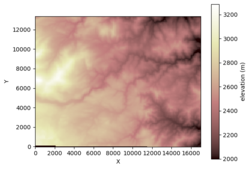
Have you ever wanted to load elevation data from online, reproject this to an appropriate model coordinate system, maybe use some GRASS GIS tools, and then use this data as the basis of your Landlab model grid? Then look no further!
This notebook:
Imports SRTM elevation data into a GRASS project using bmi_topography.
Offers opportunities for advanced GRASS calculations using imported elevation data.
Loads a GRASS layer (the STRM elevation data imported earlier) as a Landlab RasterModelGrid for future modeling endeavors.
Exports elevation data from GRASS GIS as a .tif file
Classroom organization TBD
Learning objectives Skills
Using a Data Component
Using GRASS GIS
Creating a Landlab grid
Key concepts
Digital elevation model
Coordinate reference systems
Reprojection
Model grids
Lab notes This lab can be run on the lab (for educators) and jupyter (for general use) instances of the OpenEarthscape JupyterHub: just click one of the links under the Run online using heading at the top of this page, then run the notebook in the "CSDMS" kernel.
If you don't already have a JupyterHub account, follow the instructions to sign up at https://csdms.colorado.edu/wiki/JupyterHub. If you're an educator, you can get JupyterHub accounts for students--please contact us through the CSDMS Help Desk: https://csdms.github.io/help-desk.