Revision as of 11:58, 20 December 2021 by Mpiper(talk | contribs)(Created page with "{{Labbasics |Labtitle=Topography Data Component |LabCOModule=1 of 1 |LabDateContributedOrUpdated=2021-12-20 |LabDescriptionShort=Learn how to download and access NASA SRTM and...")
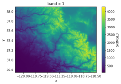
Topography is a Python library to fetch and cache NASA Shuttle Radar Topography Mission (SRTM) and JAXA Advanced Land Observing Satellite (ALOS) land elevation data using the OpenTopography REST API.
The Topography library provides access to the following global raster datasets:
   SRTM GL3 (90m)
   SRTM GL1 (30m)
   SRTM GL1 (Ellipsoidal)
   ALOS World 3D (30m)
   ALOS World 3D (30m, Ellipsoidal)
The library includes an API and CLI that accept the dataset type, a latitude-longitude bounding box, and the output file format. Data are downloaded from OpenTopography and cached locally. The cache is checked before downloading new data. Data from a cached file can optionally be loaded into an xarray DataArray using the experimental open_rasterio method.
This lab includes examples of using the Topography data component in a Jupyter Notebook, in a shell script, and in a Python program.
Acknowledgements This work is supported by the National Science Foundation under Award No. 2026951, EarthCube Capabilities: Cloud-Based Accessible and Reproducible Modeling for Water and Sediment Research.