Deprecated: Use of MediaWiki\Parser\ParserOutput::getText was deprecated in MediaWiki 1.42. [Called from SMW\MediaWiki\Hooks\OutputPageParserOutput::getParserOutput in /var/www/html/csdms.colorado.edu/csdms_wiki/extensions/SemanticMediaWiki/src/MediaWiki/Hooks/OutputPageParserOutput.php at line 161] in /var/www/html/csdms.colorado.edu/csdms_wiki/includes/debug/MWDebug.php on line 386
File:Topography.png • CSDMS: Community Surface Dynamics Modeling System. Explore Earth's surface with community software

File:Topography.png

From CSDMS
Revision as of 12:40, 20 December 2021 by Mpiper (talk | contribs) (An example of visualizing land elevation data downloaded with the Topography data component.)
(diff) ← Older revision | Latest revision (diff) | Newer revision → (diff)

Topography.png (399 × 278 pixels, file size: 99 KB, MIME type: image/png)

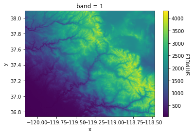
An example of visualizing land elevation data downloaded with the Topography data component.

File history

Click on a date/time to view the file as it appeared at that time.

Date/TimeThumbnailDimensionsUserComment
delete allcurrent12:40, 20 December 2021Thumbnail for version as of 12:40, 20 December 2021399 × 278 (99 KB)Mpiper (talk | contribs)An example of visualizing land elevation data downloaded with the Topography data component.

The following 2 pages use this file:

Metadata