Meeting:Abstract 2011 CSDMS meeting-007
| You probably paid. If not: | 
|
"USA" is not in the list (Afghanistan, Albania, Algeria, Andorra, Angola, Antigua and Barbuda, Argentina, Armenia, Australia, Austria, ...) of allowed values for the "Country member" property.
Browse abstracts
High resolution surface process modeling in a GRASS GIS environment
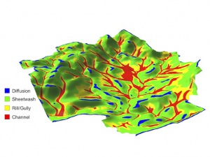
[[Image:|300px|right|link=File:]]As part of the Mediterranean Landscape Dynamics (MedLand) project to create a modeling laboratory for human-landscape interaction, we have developed a suite of landscape evolution tools in the GRASS GIS environment. The core of this tool set is a Python script to estimate sediment transport for hillslopes, gullies/rills, and small channels, and simulate resulting terrain change for high-resolution 3D digital landscapes. Because it takes advantage of raster-optimized routines in GRASS, it is very fast on normal desktop systems, making it ideal for simulating long-term landscape change resulting from human activity, climate change, or other drivers. We provide examples of how this landscape evolution model is being used in the MedLand project.

