Caitlin Haedrich at North Carolina State University.
Shelby Ahrendt at U.S. Geological Survey.
Introduction
Have you ever wanted to load elevation data from an online data source, reproject the data into an appropriate model coordinate system, maybe use some GRASS GIS tools, and then use this data as the basis of your Landlab model grid?
Then look no further!
Classroom organization This notebook:
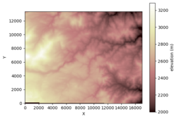
Imports SRTM elevation data into a GRASS project using the Topography Data Component (bmi-topography).
Offers opportunities for advanced GRASS calculations using imported elevation data.
Loads a GRASS layer as a Landlab RasterModelGrid for future modeling endeavors.
Exports elevation data from GRASS GIS as a .tif file
Learning objectives Skills
Using a Data Component
Using GRASS GIS
Creating a Landlab grid
Key concepts
Digital elevation model
Coordinate reference system
Reprojection
Model grid
Lab notes This lab can be run on the lab (for educators) and jupyter (for general research) instances of EarthscapeHub: just click one of the links under the "Run online using" heading at the top of this page, then run the notebook in the "GRASS GIS" kernel.