Data:Global Cropland Area (1960-2100): Difference between revisions
m (WikiSysop moved page Data:Global Cropland Area (1960-2100) to Temp:Global Cropland Area (1960-2100) without leaving a redirect) |
m (WikiSysop moved page Temp:Global Cropland Area (1960-2100) to Data:Global Cropland Area (1960-2100) without leaving a redirect) |
||
(No difference)
| |||
Latest revision as of 08:30, 22 July 2015
Global Cropland Area (1960-2100) dataset information page
Short Description
 |
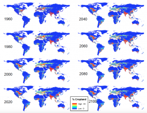
| Maps of GLUDM-predicted cropland area (Figure 8 in Haney and Cohen 2015) |
Statement: Global Cropland Area predictions by the GLUDM model
Abstract: An output of the Global Land Use Dynamics Model (GLUDM). Spatially explicit global estimates of cropland area between 1960-2099. Yearly time steps in individual NetCDF files.
The GLUDM is based on pixel-specific regression between historic land use changes and global population. Land use expansion and abandonment is governed by environmental and land use restrictions (e.g altitude and urbanization).
Fro more detailes see:
Haney, N., Cohen, S. (2015), Predicting 21st century global agricultural land use with a spatially and temporally explicit regression-based model. Applied Geography, 62: 366-376. doi:10.1016/j.apgeog.2015.05.010
Data format
| Data type: | Land Cover |
| Data origin: | Modeled |
| Data format: | NetCDF |
| Other format: | |
| Data resolution: | 0.1 arc-min |
| Datum: | lat-long |
Data Coverage
Spatial data coverage: Global
Temporal data coverage: Time series
Time period covered: 1960-2099
Availability
Download data: http://sdml.ua.edu/datasets-2/
Data source: http://sdml.ua.edu/datasets-2/
References
- Haney, N., Cohen, S. (2015), Predicting 21st century global agricultural land use with a spatially and temporally explicit regression-based model. Applied Geography, 62: 366-376. doi:10.1016/j.apgeog.2015.05.010
