Alldata:Global Forest Heights: Difference between revisions
From CSDMS
Created page with "{{Data description |One-line data description=Forest canopy height globally with spaceborne lidar |Extended data description=Data from spaceborne light detection and ranging (..." |
m WikiSysop moved page Data:Global Forest Heights to Alldata:Global Forest Heights without leaving a redirect |
(No difference)
| |
Latest revision as of 09:37, 11 March 2025
Global Forest Heights dataset information page
Short Description
 |
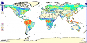
| Global forest canopy height |
Statement: Forest canopy height globally with spaceborne lidar
Abstract: Data from spaceborne light detection and ranging (lidar) opens the possibility to map forest vertical structure globally. Presented here is a wall-to-wall, global map of canopy height at 1-km spatial resolution, using 2005 data from the Geoscience Laser Altimeter System (GLAS) aboard ICESat (Ice, Cloud, and land Elevation Satellite).
Data format
| Data type: | Land Cover |
| Data origin: | Measured |
| Data format: | GeoTIFF, NetCDF, ASCII |
| Other format: | |
| Data resolution: | 1km |
| Datum: | WGS 84 (EPSG:4326) |
Data Coverage
Spatial data coverage: Global
Temporal data coverage: Time snap shot
Time period covered: 2005
Availability
Download data: http://webmap.ornl.gov/wcsdown/dataset.jsp?ds id=10023
Data source: http://www.nasa.gov/topics/earth/features/forest-height-map.html
References
- Simard, M., N. Pinto, J. B. Fisher, and A. Baccini (2011), Mapping forest canopy height globally with spaceborne lidar, J. Geophys. Res., 116, G04021, doi:10.1029/2011JG001708.
