Data:SoilGrids — global gridded soil information: Difference between revisions
(Created page with "{{Data description |One-line data description=SoilGrids<sub>TM</sub> is a system for global digital soil mapping that uses state-of-the-art machine learning methods to map the spatial distribution of soil properties across the globe. |Extended data description=SoilGrids produces maps of soil properties for the entire globe at medium spatial resolution (250 m cell size) using state-of-the-art machine learning methods to generate the necessary models. It takes as inputs so...") |
No edit summary |
||
| Line 3: | Line 3: | ||
|Extended data description=SoilGrids produces maps of soil properties for the entire globe at medium spatial resolution (250 m cell size) using state-of-the-art machine learning methods to generate the necessary models. It takes as inputs soil observations from about 240 000 locations worldwide and over 400 global environmental covariates describing vegetation, terrain morphology, climate, geology and hydrology. | |Extended data description=SoilGrids produces maps of soil properties for the entire globe at medium spatial resolution (250 m cell size) using state-of-the-art machine learning methods to generate the necessary models. It takes as inputs soil observations from about 240 000 locations worldwide and over 400 global environmental covariates describing vegetation, terrain morphology, climate, geology and hydrology. | ||
|Upload image dataset=Soil-7-217-2021-avatar-thumb150.png | |Upload image dataset=Soil-7-217-2021-avatar-thumb150.png | ||
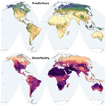
|Caption dataset image=Mean soil organic carbon content (dg/kg) prediction and range between 5 % and 95 % quantiles in the 5 to 15 cm depth interval, (a) for prediction and (b) for interquartile range. | |Caption dataset image=Mean soil organic carbon content (dg/kg)<br>prediction and range between 5 %<br>and 95 % quantiles in the 5<br>to 15 cm depth interval, (a) for prediction<br>and (b) for interquartile range. | ||
}} | }} | ||
{{Data format | {{Data format | ||
Latest revision as of 08:37, 23 June 2024
SoilGrids — global gridded soil information dataset information page
Short Description
| Mean soil organic carbon content (dg/kg) prediction and range between 5 % and 95 % quantiles in the 5 to 15 cm depth interval, (a) for prediction and (b) for interquartile range. |
Statement: SoilGridsTM is a system for global digital soil mapping that uses state-of-the-art machine learning methods to map the spatial distribution of soil properties across the globe.
Abstract: SoilGrids produces maps of soil properties for the entire globe at medium spatial resolution (250 m cell size) using state-of-the-art machine learning methods to generate the necessary models. It takes as inputs soil observations from about 240 000 locations worldwide and over 400 global environmental covariates describing vegetation, terrain morphology, climate, geology and hydrology.
Data format
| Data type: | Surface properties |
| Data origin: | Measured |
| Data format: | GeoTIFF |
| Other format: | VRT |
| Data resolution: | 250m x 250m |
| Datum: |
Data Coverage
Spatial data coverage: Global
Temporal data coverage: Time snap shot
Time period covered:
Availability
Download data: https://files.isric.org/soilgrids/latest/data/
Data source: https://www.isric.org/explore/soilgrids
References
- Poggio, L., de Sousa, L. M., Batjes, N. H., Heuvelink, G. B. M., Kempen, B., Ribeiro, E., and Rossiter, D., 2021. SoilGrids 2.0: producing soil information for the globe with quantified spatial uncertainty, SOIL, 7, 217–240, https://doi.org/10.5194/soil-7-217-2021.

