Data:LUSoils v.1: Difference between revisions
No edit summary |
No edit summary |
||
| Line 2: | Line 2: | ||
|One-line data description=Linking global land use and land cover to hydrologic soil groups from 850 to 2015. | |One-line data description=Linking global land use and land cover to hydrologic soil groups from 850 to 2015. | ||
|Extended data description=This dataset links human land use and land cover types from the Land-Use Harmonization (LUH2) dataset (Lawrence et al., 2016) to four hydrologic soil groups from 850 to 2015 derived from the SoilGrids250m soils dataset (Hengl et al., 2017). These groups represent sandy soils (hydrologic group A) consisting of texture classes sand, sandy-loam and loamy sand; silty soils (hydrologic group B) consisting of loam, silty-loam and silt; a mixed sand-silt-clay soils (hydrologic group C); and clayey soils (hydrologic group D) represented by clay, sandy-clay, clay-loam, silty-clay, and silt-clay-loam texture classes from the SoilGrids250m dataset. This dataset makes it possible to better link LULCs to soil types typically used for these activities potentially improving the simulation of water, energy and biogeochemical processes in Earth System Models. Additionally, it lays the foundation for simulating LULC impacts on soils that have different vulnerabilities and responses to human uses of soils. | |Extended data description=This dataset links human land use and land cover types from the Land-Use Harmonization (LUH2) dataset (Lawrence et al., 2016) to four hydrologic soil groups from 850 to 2015 derived from the SoilGrids250m soils dataset (Hengl et al., 2017). These groups represent sandy soils (hydrologic group A) consisting of texture classes sand, sandy-loam and loamy sand; silty soils (hydrologic group B) consisting of loam, silty-loam and silt; a mixed sand-silt-clay soils (hydrologic group C); and clayey soils (hydrologic group D) represented by clay, sandy-clay, clay-loam, silty-clay, and silt-clay-loam texture classes from the SoilGrids250m dataset. This dataset makes it possible to better link LULCs to soil types typically used for these activities potentially improving the simulation of water, energy and biogeochemical processes in Earth System Models. Additionally, it lays the foundation for simulating LULC impacts on soils that have different vulnerabilities and responses to human uses of soils. | ||
|Upload image dataset=LU on Soil | |Upload image dataset=LU on Soil.jpeg | ||
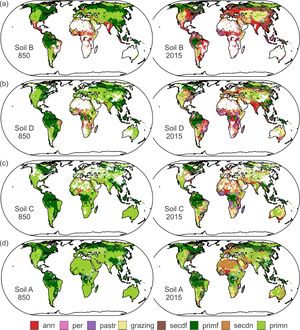
|Caption dataset image=Dominant land use and land covers on each hydrologic soil group in each grid cell of 850 and 2015 | |Caption dataset image=Dominant land use and land covers on each hydrologic soil group in each grid cell of 850 and 2015 | ||
}} | }} | ||
Revision as of 07:21, 21 February 2020
LUSoils v.1 dataset information page
Short Description
 |
| Dominant land use and land covers on each hydrologic soil group in each grid cell of 850 and 2015 |
Statement: Linking global land use and land cover to hydrologic soil groups from 850 to 2015.
Abstract: This dataset links human land use and land cover types from the Land-Use Harmonization (LUH2) dataset (Lawrence et al., 2016) to four hydrologic soil groups from 850 to 2015 derived from the SoilGrids250m soils dataset (Hengl et al., 2017). These groups represent sandy soils (hydrologic group A) consisting of texture classes sand, sandy-loam and loamy sand; silty soils (hydrologic group B) consisting of loam, silty-loam and silt; a mixed sand-silt-clay soils (hydrologic group C); and clayey soils (hydrologic group D) represented by clay, sandy-clay, clay-loam, silty-clay, and silt-clay-loam texture classes from the SoilGrids250m dataset. This dataset makes it possible to better link LULCs to soil types typically used for these activities potentially improving the simulation of water, energy and biogeochemical processes in Earth System Models. Additionally, it lays the foundation for simulating LULC impacts on soils that have different vulnerabilities and responses to human uses of soils.
Data format
| Data type: | Land Cover |
| Data origin: | Modeled |
| Data format: | KML, NetCDF, SDTS |
| Other format: | |
| Data resolution: | 0.5 degree |
| Datum: |
Data Coverage
Spatial data coverage: Global
Temporal data coverage: Time series
Time period covered: 850-2015
Availability
Download data: http://lusoil.geog.uvic.ca/dataset-linkSoilLU
Data source: http://lusoil.geog.uvic.ca/dataset-linkSoilLU
References
- Wang, P.-L. & J. Feddema, Linking Global Land Use/Land Cover to Soils from 850 to 2015, submitted to Global Biogeochemical Cycles.
