Data:ASTER: Difference between revisions
m (WikiSysop moved page Temp:ASTER to Data:ASTER without leaving a redirect) |
No edit summary |
||
| (One intermediate revision by the same user not shown) | |||
| Line 17: | Line 17: | ||
}} | }} | ||
{{Dataset availability | {{Dataset availability | ||
|Data download link= | |Data download link=https://asterweb.jpl.nasa.gov/gdem.asp | ||
|Data source link= | |Data source link=https://asterweb.jpl.nasa.gov/gdem.asp | ||
}} | }} | ||
Latest revision as of 13:13, 15 October 2019
ASTER dataset information page
Short Description
 |
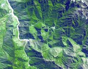
| ASTER image of Machu Picchu |
Statement: Global topography from NASA's and METI's (Japan) Terra satellite
Abstract: Advanced Spaceborne Thermal Emission and Reflection Radiometer (ASTER). The ASTER GDEM was created by stereo-correlating the 1.3 million scene ASTER VNIR archive, covering the Earth's land surface between 83N and 83S latitudes. The GDEM is produced with 30 meter postings, and is formatted in 1 x 1 degree tiles as GeoTIFF files. Each GDEM file is accompanied by a Quality Assessment file, either giving the number of ASTER scenes used to calculate a pixel's value, or indicating the source of external DEM data used to fill the ASTER voids.
Data format
| Data type: | Topography |
| Data origin: | Measured |
| Data format: | GeoTIFF |
| Other format: | |
| Data resolution: | 30 m data postings |
| Datum: |
Data Coverage
Spatial data coverage: Global (83 degrees North to 83 degrees South)
Temporal data coverage: Time snap shot
Time period covered: Continuously updated from Terra satellite
Availability
Download data: https://asterweb.jpl.nasa.gov/gdem.asp
Data source: https://asterweb.jpl.nasa.gov/gdem.asp
