Topography data: Difference between revisions
From CSDMS
No edit summary |
|||
| (15 intermediate revisions by the same user not shown) | |||
| Line 1: | Line 1: | ||
===Topography data=== | === Topography data descriptions === | ||
''This is an automatically generated table''. | |||
Want to '''add your dataset''' to this list? Please complete this [[Form:Input_data|data form]] first. Feel free to contact us [mailto:CSDMSweb@colorado.edu CSDMSweb@colorado.edu] or use the wiki and follow one of the dataset links if you want to update the information about a dataset that is already listed. | |||
Data | There are '''{{#ask: [[Alldata:+]] [[Data type::Topography]] | ||
| sort=Data origin | |||
| format=count | |||
}}''' datasets described below. | |||
<table {{Prettytable}} class = "sortable" cellspacing="0" cellpadding="0" style="margin:0em 0em 0em 0;"> | |||
Data description | <tr><th {{H13}}>Dataset info</th><th {{H13}}>Type</th><th {{H13}}>Origin</th><th {{H13}}>Description</th><th {{H13}}>Data example</th></tr> | ||
{{#ask: [[Alldata:+]] [[Data type::Topography]] | |||
| ?Data type | |||
Data | | ?One-line data description | ||
| ?Data download link | |||
| ?Upload image dataset | |||
| ?Data origin | |||
| limit=5000 | |||
| format=template | |||
| template=ask data template | |||
}}</table> | |||
Latest revision as of 09:54, 11 March 2025
Topography data descriptions
This is an automatically generated table.
Want to add your dataset to this list? Please complete this data form first. Feel free to contact us CSDMSweb@colorado.edu or use the wiki and follow one of the dataset links if you want to update the information about a dataset that is already listed.
There are 23 datasets described below.
| Dataset info | Type | Origin | Description | Data example |
|---|---|---|---|---|
| ASTER | Topography | Measured | Global topography from NASA's and METI's (Japan) Terra satellite | 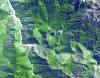 |
| Aerial images Fraser GST | Topography | Measured | Aerial images of Fraser GST zone | 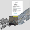 |
| CGIAR-CSI SRTM | Topography | Modeled | Improved and void-filled global topographic model of the SRTM data; 3 arc-second (~90 m) cell size | |
| Clara Orru - measured data of a degradational sand-gravel laboratory experiment | Topography | Measured | measured data from a degradational sand-gravel laboratory experiment | 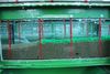 |
| Coastal DEMs | Topography | Modeled | High-resolution, integrated bathymetric-topographic relief models of U.S. coastal communities; 1/3 arc-second (~10 m) cell size and coarser | 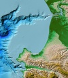 |
| ETOPO1 | Topography | Modeled | Global integrated bathymetric-topographic relief model; 1 arc-minute (~2 km) cell size | 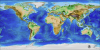 |
| GEBCO | Topography | Modeled | Global integrated bathymetric-topographic relief model; 1 arc-minute (~2 km) and 30 arc-second (~1 km) cell sizes | 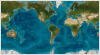 |
| GLOBE | Topography | Measured | Global topographic relief model; 30 arc-second (~1 km) cell size |  |
| GSHHG | Topography | Measured | Global Self-consistent, Hierarchical, High-resolution Geography Database |
 |
| GTOPO30 | Topography | Measured | GTOPO30 is a global digital elevation model with a horizontal resolution of 30 arc seconds. | 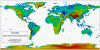 |
| Global Multibeam Bathymetry | Topography | Measured | NGDC's global database of multibeam swath sonar bathymetric surveys | 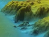 |
| Global Topography | Topography | Modeled | Global estimated bathymetric and integrated bathy-topo relief models; 1 minute (~2 km) and 30 arc-second (~1 km) cell sizes | 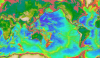 |
| Great Lakes Bathymetry | Topography | Modeled | Bathymetric models and contours of the Great Lakes; 3 arc-second (~90 m) cell size |  |
| IBCAO | Topography | Modeled | Integrated bathymetric-topographic relief model of the Arctic Ocean; 500-meter cell size | 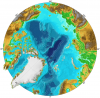 |
| MERIT DEM | Topography | Measured | The MERIT DEM was developed by removing multiple error components from existing spaceborne DEMs (SRTM3 and AW3D) | 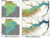 |
| Marine Geophysical Trackline Data | Topography | Measured | NGDC's global database of marine trackline surveys; contains bathymetry, magnetics, gravity and seismic navigation data | 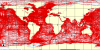 |
| NED | Topography | Modeled | U.S. National Elevation Dataset (NED) topographic relief model; 1/9 arc-second (~3 m) cell size to 2 arc-second (~60 m) cell size | 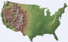 |
| NGDC Coastal Relief Model | Topography | Modeled | Integrated bathymetric-topographic relief models of U.S. coasts; 3 arc-second (~90 m) cell size | 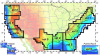 |
| NOSHDB | Topography | Measured | Database of U.S. hydrographic surveys conducted by NOAA's National Ocean Service | 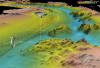 |
| OpenTopography | Topography | Modeled | Community access to high-resolution, Earth science-oriented, topography data, and related tools and resources. | 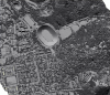 |
| SRTM | Topography | Measured | Global topography from NASA's 2000 Shuttle Radar Topography Mission (SRTM) | 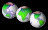 |
| Southern Alaska Coastal Relief Model | Topography | Modeled | Integrated bathymetric-topographic relief model of Southern Alaska; 24 arc-second cell size | |
| World Vector Shoreline | Topography | Measured | World Vector Shoreline | 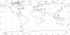 |
