Terrestrial GL8: Difference between revisions
mNo edit summary |
m removed side bar link |
||
| (8 intermediate revisions by 2 users not shown) | |||
| Line 1: | Line 1: | ||
===CSDMS Terrestrial Image Gallery=== | ===CSDMS Terrestrial Image Gallery=== | ||
{{Gallery intro}}<br> | |||
{{Terrestrial gallery pages}} | |||
<hr><gallery> | <hr><gallery> | ||
image:DSC_11LROvereem.jpg|Location:North Slope, AK<br>Date:June 2008<br>Credit: Irina Overeem<br>Keywords:<br>Description:Thaw Lakes on the North Slope of Alaska | image:DSC_11LROvereem.jpg|Location:North Slope, AK<br>Date:June 2008<br>Credit: Irina Overeem<br>Keywords:<br>Description:Thaw Lakes on the North Slope of Alaska | ||
image:DSC_12LROvereem.jpg|Location:North Slope, AK<br>Date: June 2008<br>Credit: Irina Overeem<br>Keywords:<br>Description:Partly Frozen Thaw Lakes on the North Slope of Alaska | image:DSC_12LROvereem.jpg|Location:North Slope, AK<br>Date: June 2008<br>Credit: Irina Overeem<br>Keywords:<br>Description:Partly Frozen Thaw Lakes on the North Slope of Alaska | ||
image:DSC_13LROvereem.jpg|Location:North Slope, AK<br>Date: June 2008<br>Credit: Irina Overeem<br>Keywords:<br>Description:Connected Thaw Lakes on the North Slope of Alaska | image:DSC_13LROvereem.jpg|Location:North Slope, AK<br>Date: June 2008<br>Credit: Irina Overeem<br>Keywords:<br>Description:Connected Thaw Lakes on the North Slope of Alaska | ||
image:DSC_14LROvereem.jpg|Location:North Slope, AK<br>Date: June 2008<br>Credit: Irina Overeem<br>Keywords:<br>Description:Connected Thaw Lakes and Patterned Ground | |||
image:DSC_15LROvereem.jpg|Location:North Slope, AK<br>Date: June 2008<br>Credit: Irina Overeem<br>Keywords:<br>Description:Connected Thaw Lakes on the North Slope of Alaska | |||
image:Flood_disaster.jpg|Location:earth<br>Date: June 2008<br>Credit: Irina Overeem<br>Keywords:<br>Description:Connected Thaw Lakes on the North Slope of Alaska | |||
</gallery> | </gallery> | ||
{{Terrestrial gallery pages}} | |||
Latest revision as of 10:12, 2 July 2010
CSDMS Terrestrial Image Gallery
The images on this page illustrate aspects of environments that the CSDMS Project tries to capture by a suite of models. The freely downloadable images are generously contributed by various people. Please make sure to credit the contributors when you are using these images.
Upload your images if you are willing to share your best Surface Dynamics images and movies. Make sure to add at least the next 5 attributes to each uploaded picture on the upload page in the Summary:
- Location
- Date taken
- Credit
- Keywords
- Short description
How does it work?
1) Choose one of the following galleries to add your material to:
2) Login, Upload your figure (see Toolbox, Upload); remember the image name. Go to the last gallery page, click on edit in the "page edit toolkit" and copy the last few lines from image:.... till Description:.... and insert your information in the various attribute fields.
Need help? Email:CSDMSweb@colorado.edu
Page: 1, 2, 3, 4, 5, 6, 7, 8
-
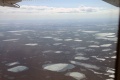 Location:North Slope, AK
Date:June 2008
Credit: Irina Overeem
Keywords:
Description:Thaw Lakes on the North Slope of Alaska -
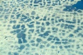
 Location:North Slope, AK
Date: June 2008
Credit: Irina Overeem
Keywords:
Description:Partly Frozen Thaw Lakes on the North Slope of Alaska -
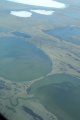 Location:North Slope, AK
Date: June 2008
Credit: Irina Overeem
Keywords:
Description:Connected Thaw Lakes on the North Slope of Alaska -
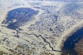 Location:North Slope, AK
Date: June 2008
Credit: Irina Overeem
Keywords:
Description:Connected Thaw Lakes and Patterned Ground -
 Location:North Slope, AK
Date: June 2008
Credit: Irina Overeem
Keywords:
Description:Connected Thaw Lakes on the North Slope of Alaska -
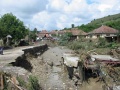 Location:earth
Date: June 2008
Credit: Irina Overeem
Keywords:
Description:Connected Thaw Lakes on the North Slope of Alaska


