|Labtitle=Data Component Use Case for Wave Power Calculation
|Labtitle=Data Component Use Case for Wave Power Calculation
|LabCOModule=1 of 1
|LabCOModule=1 of 1
|LabDateContributedOrUpdated=2023-05-04
|LabDateContributedOrUpdated=2025-07-09
|LabDescriptionShort=A demonstration of how to use the Data Component to download wave properties datasets to calculate the wave power.
|LabDescriptionShort=A demonstration of using the WAVEWATCH III Data Component to download wave properties datasets to calculate the wave power.
|LabCODuration=1.5 hrs
|LabCODuration=1.5 hrs
|LabModelDocumentation=WAVEWATCH III ^TM
|LabModelDocumentation=WAVEWATCH III ^TM
Line 20:
Line 20:
}}
}}
{{LabIntro
{{LabIntro
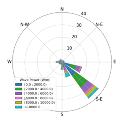
|LabDescription=Waves enhance sediment resuspension from the seabed and shorelines. Wave power is often correlated to shoreline erosion and is used to assess feasibility of renewable wave energy generation. This lab demonstrates how to use the CSDMS data component to download surface wave properties from the WAVEWATCH III model output for a given time period, interpolate it to a specific location, and calculate the wave power over time at that point.
|LabDescription=Waves enhance sediment resuspension from the seabed and shorelines. Wave power is often correlated to shoreline erosion and is used to assess feasibility of renewable wave energy generation. This lab demonstrates how to use the CSDMS Data Component to download surface wave properties from the WAVEWATCH III model output for a given time period, interpolate it to a specific location, and calculate the wave power over time at that point.
|LabPicture=Wave power.png
|LabPicture=Wave power.png
}}
}}
Line 30:
Line 30:
}}
}}
{{LabLearningObjectivesSkills
{{LabLearningObjectivesSkills
|LabSkill=Learn to use the wind properties data to calculate wind power..
|LabSkill=Learn to use the wind properties data to calculate wind power.
}}
}}
{{Headerplaceholder}}
{{Headerplaceholder}}
Line 43:
Line 43:
}}
}}
{{LabNotes
{{LabNotes
|LabNotesInstructions=This lab can be run on the lab (for educators) and jupyter (for general use) instances of the OpenEarthscape JupyterHub: just click one of the links under the Run online using heading at the top of this page, then run the notebook in the "CSDMS" kernel.
|LabNotesInstructions=<p>This lab can be run on the <em>explore</em> (for educators) and <em>jupyter</em> (for general use) instances of EarthscapeHub: just click one of the links under the <strong>Run online using</strong> heading at the top of this page, then run the notebook in the "CSDMS" kernel.</p>
<p>If you don't already have an EarthscapeHub account, follow the instructions to sign up at https://csdms.colorado.edu/wiki/JupyterHub. If you're an educator, you can get EarthscapeHub accounts for you and your students--please contact us through the CSDMS Help Desk: https://csdms.github.io/help-desk.</p>
If you don't already have a JupyterHub account, follow the instructions to sign up at https://csdms.colorado.edu/wiki/JupyterHub. If you're an educator, you can get JupyterHub accounts for students--please contact us through the CSDMS Help Desk: https://csdms.github.io/help-desk.
|LabNotesRequirements=If run locally, please follow the instruction at https://github.com/bundzis/wavewatch3_usecase
|LabNotesRequirements=If run locally, please use the environment yaml file to create a virtual environment and run the notebook (link will be added soon).
|LabAcknowledgements=This work was supported by the National Science Foundation under collaborative grants 1831623, 2026951, 2140831, 2104102, and 2148762.
|LabAcknowledgements=This work was supported by the National Science Foundation under collaborative grants 1831623, 2026951, 2140831, 2104102, and 2148762.
}}
}}
{{LabReferences
{{LabReferences
|LabReferences=Booij, N., Ris, R. C., and Holthuijsen, L. H. (1999). A third-generation wave model for coastal regions 1. Model description and validation. Journal of Geophysical Research, 104 (C4): 7649-7666.
|LabReferences=Booij, N., Ris, R. C., and Holthuijsen, L. H. (1999). A third-generation wave model for coastal regions 1. Model description and validation. Journal of Geophysical Research, 104 (C4): 7649-7666. https://doi.org/10.1029/98JC02622
}}
{{LabReferences
|LabReferences=T.W. Thorpe, "A Brief Review of Wave Energy," UK Department of Trade and Industry, ETSU-R120, 25 May 99. http://large.stanford.edu/courses/2011/ph240/yan1/docs/thorpe.pdf
}}
}}
{{LabReferences
{{LabReferences
|LabReferences=T.W. Thorpe, "A Brief Review of Wave Energy," UK Department of Trade and Industry, ETSU-R120, 25 May 99. http://www.homepages.ed.ac.uk/shs/Wave%20Energy/Tom%20Thorpe%20report.pdf
|LabReferences=Gan, T., Tucker, G.E., Hutton, E.W.H., Piper, M.D., Overeem, I., Kettner, A.J., Campforts, B., Moriarty, J.M., Undzis, B., Pierce, E., McCready, L., 2024: CSDMS Data Components: data–model integration tools for Earth surface processes modeling. Geosci. Model Dev., 17, 2165–2185. https://doi.org/10.5194/gmd-17-2165-2024
}}
}}
Latest revision as of 13:51, 9 July 2025
Data Component Use Case for Wave Power Calculation
Brianna Undzis at Atmospheric and Oceanic Sciences - University of Colorado Boulder.
Julia Moriarty at Atmospheric and Oceanic Sciences - University of Colorado Boulder.
Introduction
Waves enhance sediment resuspension from the seabed and shorelines. Wave power is often correlated to shoreline erosion and is used to assess feasibility of renewable wave energy generation. This lab demonstrates how to use the CSDMS Data Component to download surface wave properties from the WAVEWATCH III model output for a given time period, interpolate it to a specific location, and calculate the wave power over time at that point.
Classroom organization In this lab, we will use the WAVEWATCH III Data Component to download the model output from the WAVEWATCH III model, including significant wave height, peak wave period, peak wave direction, windspeed in east-west direction, and windspeed in the north-south direction. These datasets are interpolated to a location on the Northern Gulf of Mexico continental shelf (28.8°N, 267.4°E). Wave power is then calculated using the significant wave height and peak wave period for this location.
Learning objectives Skills
Learn to use Data Components to download research datasets.
Learn to use the wind properties data to calculate wind power.
Key concepts
WAVEWATCH III
Wave power
CSDMS Data Component
Lab notes
This lab can be run on the explore (for educators) and jupyter (for general use) instances of EarthscapeHub: just click one of the links under the Run online using heading at the top of this page, then run the notebook in the "CSDMS" kernel.
If you don't already have an EarthscapeHub account, follow the instructions to sign up at https://csdms.colorado.edu/wiki/JupyterHub. If you're an educator, you can get EarthscapeHub accounts for you and your students--please contact us through the CSDMS Help Desk: https://csdms.github.io/help-desk.
Acknowledgements This work was supported by the National Science Foundation under collaborative grants 1831623, 2026951, 2140831, 2104102, and 2148762.
References
Booij, N., Ris, R. C., and Holthuijsen, L. H. (1999). A third-generation wave model for coastal regions 1. Model description and validation. Journal of Geophysical Research, 104 (C4): 7649-7666. https://doi.org/10.1029/98JC02622