Model:AlluvStrat

From CSDMS


AlluvStrat


Metadata

Also known as
Model type Single
Model part of larger framework
Note on status model
Date note status model
Incorporated models or components:
Spatial dimensions 2D
Spatial extent Landscape-Scale, Watershed-Scale, Reach-Scale
Model domain Coastal, Terrestrial
One-line model description Rules-based model to generate a 2-dimensional cross section of alluvial stratigraphy based on fluvial processes
Extended model description Generates alluvial stratigraphy by channel migration and avulsion. Channel migration is handled via a random walk. Avulsions occur when the channel superelevates. Channels can create levees. Post-avulsion channel locations chosen at random, or based on topography.
Keywords:

stratigraphy, fluvial,

Name Andy Wickert
Type of contact Model developer
Institute / Organization University of Colorado
Postal address 1 UCB 450
Postal address 2 1560 30th St
Town / City Boulder
Postal code 80303
State Colorado
Country United States
Email address wickert@colorado.edu
Phone
Fax


Supported platforms
Linux
Other platform Probably works on all, but is untested
Programming language

Python

Other program language
Code optimized Single Processor
Multiple processors implemented
Nr of distributed processors
Nr of shared processors
Start year development 2011
Does model development still take place? Yes
If above answer is no, provide end year model development
Code development status
When did you indicate the 'code development status'?
Model availability As code
Source code availability
(Or provide future intension)
Through web repository, Through CSDMS repository
Source web address https://github.com/awickert/alluvstrat
Source csdms web address
Program license type GPL v2
Program license type other
Memory requirements ?
Typical run time seconds to minutes


Describe input parameters Input file: channel width and depth, a few others
Input format ASCII
Other input format
Describe output parameters Numpy array of channel and overbank deposit
Output format Binary
Other output format
Pre-processing software needed? No
Describe pre-processing software
Post-processing software needed? No
Describe post-processing software
Visualization software needed? No
If above answer is yes
Other visualization software


Describe processes represented by the model Channel migration and avulsion building stratigrpahy
Describe key physical parameters and equations
Describe length scale and resolution constraints
Describe time scale and resolution constraints
Describe any numerical limitations and issues


Describe available calibration data sets
Upload calibration data sets if available:
Describe available test data sets
Upload test data sets if available:
Describe ideal data for testing Subsurface data that comprise channel and overbank deposits in a setting where avulsion magnitudes and frequencies and channel migration rates are known


Do you have current or future plans for collaborating with other researchers? Yep! Working on it.
Is there a manual available? No
Upload manual if available:
Model website if any
Model forum / discussion board
Comments Barely started; using this as a testbed for the new CSDMS BMI interface.


This part will be filled out by CSDMS staff

OpenMI compliant No but possible
BMI compliant No but possible
WMT component In progress
PyMT component
Is this a data component
DOI model 10.1594/IEDA/100088
For model version 0.1
Year version submitted 2012
Link to file
Can be coupled with:
Model info

  • Download AlluvStrat [ version: 0.1]
    Doi: 10.1594/IEDA/100088
Nr. of publications: 1
Total citations: 0
h-index: --"--" is not a number.
m-quotient: 0
Qrcode AlluvStrat.png
Link to this page


Introduction

AlluvStrat is a simple rules-based model that generates fluvial stratigraphy based on channel width and depth, channel migration rate, channel aggradation rate, and an exponential decay constant for levee growth. Channels move directly by lateral migration, or by avulsion once they aggrade a full channel depth (i.e. superelevation = 1). The channels build overbank materials to their sides, and erode overbank materials where they pass through them.

The current boundary conditions force channel positions that would pass through a periodic boundary condition to remain stuck to the domain boundaries; I am curious as to whether or not this matches observations from physical experiments.

History

References


Nr. of publications: 1
Total citations: 0
h-index: --"--" is not a number.
m-quotient: 0


Featured publication(s)YearModel describedType of ReferenceCitations
Wickert, A.D. 2012. AlluvStrat, version 0.1.. , , . 10.1594/IEDA/100088
(View/edit entry)
2012 AlluvStrat

Source code ref.

0
See more publications of AlluvStrat


Issues

Help

Input Files

A single plain text file in the directory, called "input", provides parameters for the model. The contents of this file are pasted here:

; Input file for fluvial stratigraphy code (ADW, 27 DEC)

[grid]
dz = 0.1 ; vertical cell size [m]
dy = 1 ; lateral cell size [m]
B = 2001 ; domain width [m]

[time]
dt = 1 ; time step size [yr]
nt = 10000 ; total time steps for model run [--]

[channel]
b = 201 ; meters, must be odd and multiple of dx
h = 5 ; meters
eta = 0 ; Starting bed elevation; should probably stay at zero
etadot_ch = 0.01 ; aggradation rate [m/yr]
zetadot = 1 ; lateral migration rate [m/yr]

[overbank]
; Should include options of different overbank aggradation schemes
etadot_ob_xstar = 200 ; [m] levee exponential decay constant

Output Files

Plots

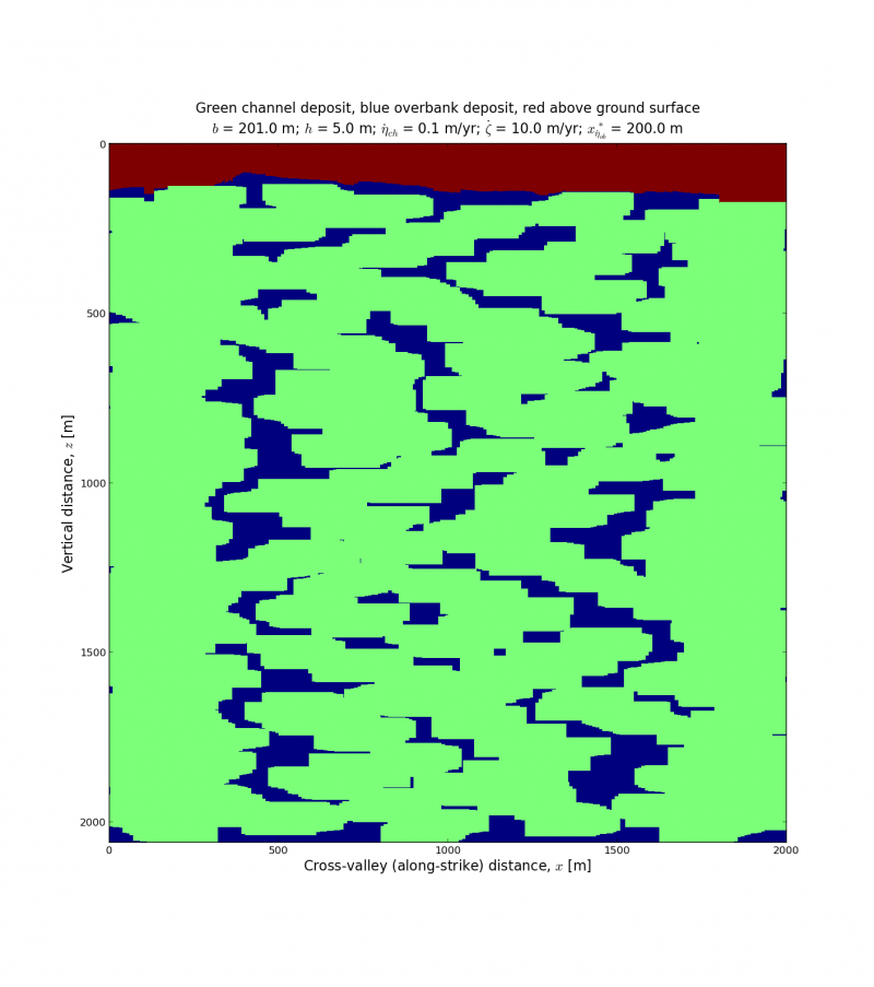
The following are plots of some example output. Relevant parameters are listed in the plots:

  • [math]\displaystyle{ b }[/math]: Channel width
  • [math]\displaystyle{ h }[/math]: Channel depth
  • [math]\displaystyle{ \dot{\eta}_{ch} }[/math]: In-channel aggradation rate
  • [math]\displaystyle{ \dot{\zeta} }[/math]: Channel lateral migration rate
  • [math]\displaystyle{ x^*_{\dot{\eta}_{ob}} }[/math]: Floodplain levee height exponential decay length

All of these simulations were run for 10,000 years on a 2001 meter wide domain. Due to the boundary conditions of the current version of the model (trunk on 08 April 2013), there is some clustering of channel bodies around the edges.

AlluvStrat example 0.png AlluvStrat example 1.pngAlluvStrat example 2.pngAlluvStrat example 3.pngAlluvStrat example 4.png

Data

The program does not yet save the output grid. We'll have to update the code, or you can run it in an interactive session like ipython and then save the output.