MeetingOfInterest:Meeting-308
From CSDMS
Flood Risk Workshop
SEEC building
Boulder Colorado, United States
01 - 03 October 2018
Boulder Colorado, United States
01 - 03 October 2018
|
Deadlines
Abstract submission: The abstract submission deadline has passed Registration: Registration is now closed
Official website
Meeting contact
|
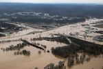
People in academia, industry (R&D), and government agencies are investigating and attempting to identify flood risk areas and predict changes in flood risk at large spatial and temporal scales. There is a recognized need to identify flood risk and exposure at higher resolution and with greater precision. Applied research studies either use satellite data to map hazard and exposure to flooding at large scales or use models that are typically run with stochastic data or flow return periods, with large uncertainties about extreme events like floods in the distribution tails. Furthermore, exposure and derived vulnerability data are often licensed or of restricted access. New technologies (e.g. small and cube-satellites, drones), advances in Artificial Intelligence (AI), improved use of crowdsources, social media and available census and other data, and interoperability standards, however, promise significant, even game changing, progress in this field for the coming years.
Flood risk assessments of both exposure and vulnerability should leverage the best available data- but often those producing or using such assessments are unaware of what is available.
In order to maximize exchange and value of required data and models, collaborative partnerships between private and public entities must be established. There is a clear need to bring together government agencies, humanitarian aid organizations, insurance and re-insurance providers, private sector industries, as well as academic and research institutions to increase collaboration and improve access to and flow of information around flood risk.