Data:SRTM
SRTM dataset information page
Short Description
 |
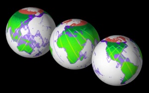
| SRTM coverage map of Earth |
Statement: Global topography from NASA's 2000 Shuttle Radar Topography Mission (SRTM)
Abstract: The Shuttle Radar Topography Mission (SRTM) obtained elevation data on a near-global scale to generate the most complete high-resolution digital topographic database of Earth between 56 degrees south and 60 degrees north latitude. SRTM consisted of a specially modified radar system that flew onboard the Space Shuttle Endeavour during an 11-day mission in February of 2000.
NASA has released version 2 of the Shuttle Radar Topography Mission digital topographic data (also known as the "finished" version). Version 2 is the result of a substantial editing effort by the National Geospatial Intelligence Agency and exhibits well-defined water bodies and coastlines and the absence of spikes and wells (single pixel errors), although some areas of missing data ('voids') are still present. The Version 2 directory also contains the vector coastline mask derived by NGA during the editing, called the SRTM Water Body Data (SWBD), in ESRI Shapefile format.
Version 2.1 is a recalculation of the SRTM3 (nominal 90 meter sample spacing) version made by 3x3 averaging of the full resolution edited data. Version 2 had been generated by masking in edited samples from the lower-resolution publicly released by the NGA, and contained occasional artifacts, and in particular a slight vertical “banding” in databeyond 50° latitude. These have been eliminated in Version 2.1
SRTM data are distributed in two levels: SRTM1 (for the U.S. and its territories and possessions) with data sampled at one arc-second intervals in latitude and longitude, and SRTM3 (for the world) sampled at three arc-seconds. Three arc-second data are generated by three by three averaging of the one arc-second samples.
Data format
| Data type: | Topography |
| Data origin: | Measured |
| Data format: | BIL |
| Other format: | |
| Data resolution: | 3 arc-second (~90 m) cell size (global), 1 arc-second (~30 m) cell size (U.S.) |
| Datum: | WGS 84 ellipsoid |
Data Coverage
Spatial data coverage: Global: 56 degrees South to 60 degrees North latitude
Temporal data coverage: Time snap shot
Time period covered: Feb 2000
Availability
Download data: http://dds.cr.usgs.gov/srtm/
Data source: http://www2.jpl.nasa.gov/srtm/
