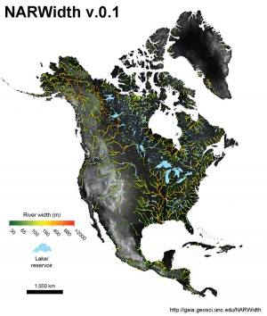
Data:North American River Width Data Set (NARWidth)
From CSDMS
North American River Width Data Set (NARWidth) dataset information page
Short Description
 |
| North American River Width composed from Landsat imagery |
Statement: NARWidth is composed of planform morphometric measurements of North American rivers at approximately mean discharge
Abstract: NARWidth is composed of planform morphometric measurements of North American rivers at approximately mean discharge. It was created using image processing algorithms on Landsat TM and ETM+ imagery. NARWidth is intended to be used in a wide variety of scientific and engineering applications including hydrologic, hydraulic, and biogeochemical models.
Data format
| Data type: | Hydrography |
| Data origin: | Measured |
| Data format: | Shapefile, CSV |
| Other format: | |
| Data resolution: | 30m |
| Datum: | WGS84 |
Data Coverage
Spatial data coverage: North America
Temporal data coverage: Time snap shot
Time period covered:
Availability
Download data: http://gaia.geosci.unc.edu/NARWidth/download.html
Data source: http://gaia.geosci.unc.edu/NARWidth/
References
- Allen, G. H., Pavelsky T.M., (2015), Patterns of river width and surface area newly revealed by the satellite-derived North American River Width data set. Geophysical Research Letters. doi: 10.1002/2014GL062764
